
ColCo
Enhancing Cocoa Farming with AI and Geospatial Technologies
Colombian Cacao
Cocoa cultivation, essential for the chocolate industry and small farming communities, plays a significant role in Colombia's economy. According to the International Cocoa Organization (ICCO), in 2020 Colombia ranked tenth in the world in terms of annual cocoa production. Colombia harvests cacao year-round, and the cacao production year runs from October to September. Most producers farm an average of three hectares of cacao.
Main Colombian Cacao Producing Departments Source: Colombian Ministry of Agriculture and Rural Development and the Colombian Cacao Producers Association
Cacao Diseases
Cacao diseases cause a major threat to production which impacts yields and farmer livelihoods. These diseases develop due to environmental conditions, requiring farmers to effectively manage and sustain healthy crops to ensure quality. Below, you will find the most common diseases affecting cacao pods.
Frosty Pod Rot
Moniliphthora roreri, a fungus found in Central and South America causes this disease which could destroy up to 90 percent of the cacao pods. Below are factors that affect the growth and appearance of Frosty Pod Rot.
- Humidity: High humidity causes the germination and spread of spores. Prolonged wet conditions also allow the fungus to thrive, which causes increased infection rates.
- Temperature: High temperatures (>30°C) promote rapid spore production.
- Elevation: More common in low to mid-elevation regions (below 1200 meters).
- Light intensity: Depending on how shade trees are arranged can affect how much light gets through, which can impact frosty pod rot.
- Soil Moisture: Excessive soil moisture creates an environment that promotes the growth and spread of frosty pod rot.
In Perú frosty pod rot has led to the loss of over 16,500 hectares of cacao, which is more than 50% of the cultivated area. Similarly in Costa Rica, around 7,000 hectares of cacao were abandoned. In Colombia, regions such as San Vicente del Caguán (Department of Caquetá) and various municipalities in the Department of Chocó have experienced pod losses exceeding 80 percent, resulting in the widespread abandonment of cacao farms.

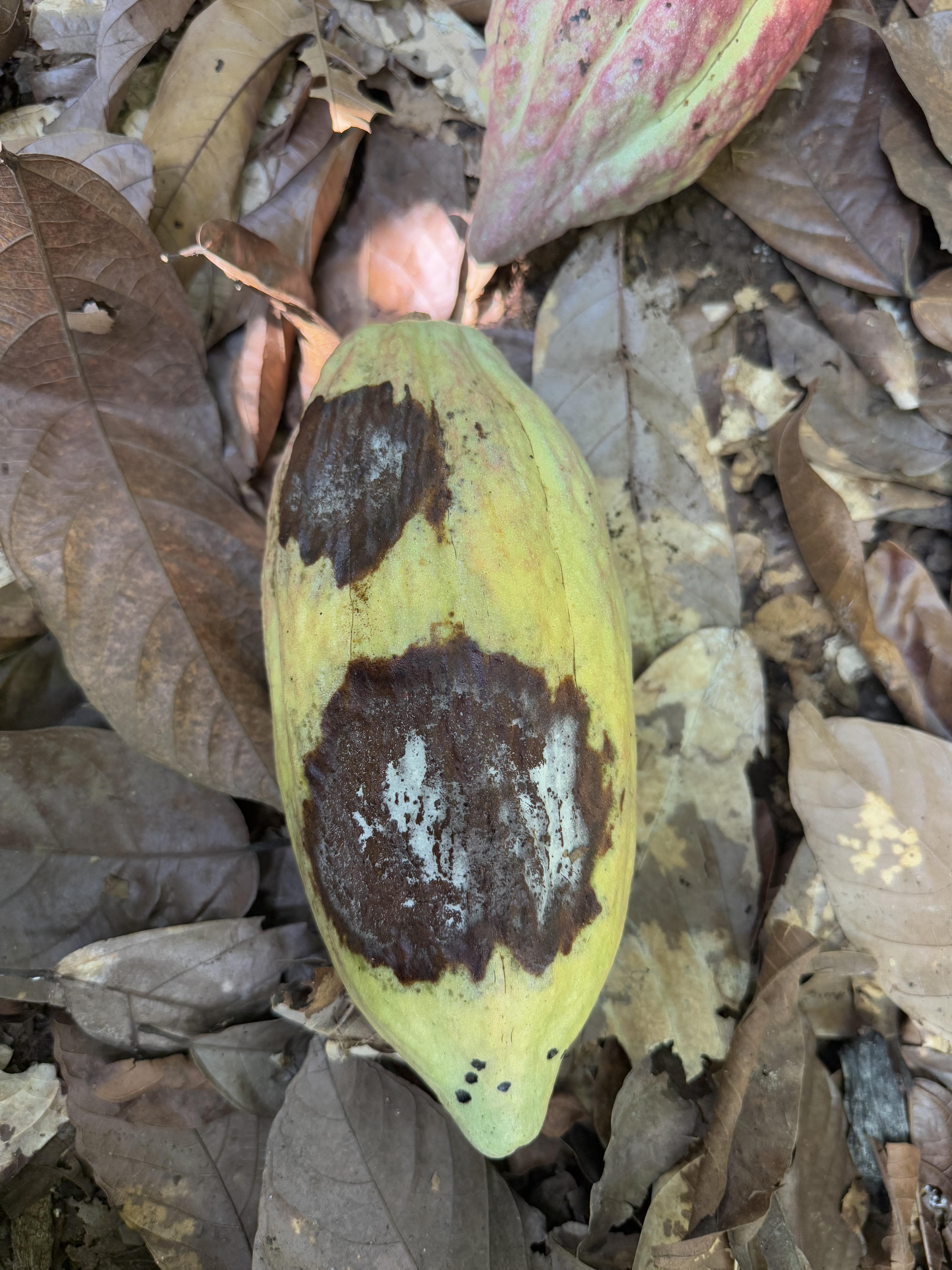
Black Pod
Phytophthora palmivora is a pathogen with significantly affects cacao agriculture in Colombia. They cause diseases that severely reduce yields in tropical and temperate climates. It can reduce the yields by up to 30-50% in Cacao farms. Below are factors that affect the growth and appearance of Black Pod.
- Humidity: Above 90% creates ideal conditions for spore dispersal and infection.
- Temperature: Warmer tropical climates (25-30°C).
- Elevation: Lower elevations (up to 800 meters).
- Light intensity: A light intensity of 64.11% supports cacao growth, but imbalances can stress plants, affecting yield and disease resistance. Proper light management is crucial for healthy pod development.
- Soil Moisture: Consistent wet conditions can promote fungal production and root infections.
Black pod disease has significantly impacted cacao production in Colombia. Regions such as San Vicente del Caguán in the Caquetá department were led to several plantations being abandoned. Due to high moisture levels in the soil and humid conditions, these regions have more of an impact. Cacao farmers face losses of up to 40% of their crop yield annually due to black pod disease.


Effects in Colombia
Colombian cacao production has been facing significant challenges. With 16.7 million hectares, these suitable lands play a vital role in the country's cacao cultivation. However in recent years climate-related factors and disease outbreaks have severely impacted productivity. This section highlights visual data representing the impact of these issues.
Cause/Problem
Source: Colombian Ministry of Agriculture and Rural Development and the Colombian Cacao Producers Association
In 2023, cacao production in Colombia dropped to 59, 831 MT (metric tons), which is a 13% decrease from 2021. Due to constant climate changes and disease outbreaks such as frosty pod rot, this has led to a decline in cocoa production. The excessive rainfalls in Colombia has increased the spread of frosty pod rot, leading to poor soil quality and growing conditions.
Figure 2, sourced from González-Orozco, C. E., & Pesca, A. (2022). Regionalization of Cacao (Theobroma cacao L.) in Colombia.
A study by Carlos E. González-Orozco and Allende Pesca analyzed nearly 5,000 cacao farms, identifying four key regions influenced by climate. High humidity and specific temperature ranges, especially in the Pacific region of Nariño, creates conditions for fungal diseases such as frosty pod rot, affects cacao growth stages, and increases moisture retention in the soil and air.
Figure 3, sourced from González-Orozco, C. E., & Pesca, A. (2022). Regionalization of Cacao (Theobroma cacao L.) in Colombia.
Regions in northern Colombia receive the highest solar radiation (Fig. 2A), while southern Andean areas face significant soil temperature fluctuations (Fig. 2B). The hyper-humid Pacific regions, including Chocó and Valle del Cauca (Fig. 3 sub-region 4c), and areas bordering Chocó-Darién (Fig 3sub-region 2c), experience high humidity, increasing the risk of frosty pod rot. The central province (Fig 3 sub-region 2b) is a transitional zone, shifting from hot and dry to wet and humid, impacting cacao growth.
Methodology
This project focuses on Granja Luker farm, Palestina. It integrates machine learning, geospatial analytics, and sensor networks to transform disease management and support sustainable farming practices. A deep learning model is used to identify diseases from images for cocoa pods, while geolocation data helps uncover reginal patterns influenced by weather conditions. Additionally sensor nodes collect soil an environmental data, providing insight that will improve the accuracy of our disease predictions
Part 1: Disease Detection & Geotagging
To detect visible symptoms of cocoa pod diseases, we are currently using deep learning models such as convolutional neural network (CNN) and Random Forest Classifier (RFC). The key steps involved are:
- Dataset Overview: The Enfermedades Cacao YOLOv4 dataset, obtained from Kaggle, features images of cocoa pods, both healthy and unhealthy. The diseases included in these dataset are Fito and Monilia. This dataset is utilized to train our Machine learning model for accurate disease detection and classification.
- Image Preprocessing: Techniques such as contrast enhancement, noise reduction and augmentation (rotation, scaling, cropping) are applied to improve the dataset quality
Image Preprocessing Technique: Contrast Enhancement
- Feature Extraction & Classification: When using CNN, it analyzes images to detect features such as color irregularities, texture changes, and lesions. This catches early-stage detection of diseases such as discoloration or fungal growth. A RFC is used to make the final disease classification.
- Geotagging: Data is geotagged and integrated with GIS tools to create interactive maps highlighting areas of high disease risk. The images were captured by our team members in Colombia. Additionally, when a user takes and submits a picture, their location is recorded, helping the model understand the context of the disease based on climate and environmental conditions.
Getting camera and geolocation of the images
Part 2: Sensor Deployment & Workflow
GPS modules and hardware sensors are deployed in cocoa farms to collect critical environmental data.
Workflow to use ColCo platform
- Sensor Deployment: A network of sensors per acre is strategically placed to monitor key variables such as temperature, humidity, and soil moisture.
- Data Collection: Sensors continuously relay data to a centralized system, enabling real-time monitoring of environmental conditions that contribute to disease risk.
- Predictive Modeling: Using the collected data, machine learning models analyze patterns to predict potential disease hotspots. For instance, high humidity combined with low soil pH is strongly correlated with black pod disease.
Results
We plan to integrate a map that highlights critical zones using a two-tier color-coded system to represent varying levels of weather-related risk. Red will indicate high-risk areas, yellow will signify low-risk zones, and other areas will represent safe regions with no immediate danger from weather conditions. This visual representation aims to provide users with clear and intuitive insights into the severity of weather impacts in different areas, enabling better decision-making and preparedness.
Hypothetical concept for the Danger Zones Map
Future Work
Our next steps for this project focus on enhancing the accuracy of our machine learning models by integrating advanced image processing techniques to enhance our results. With our team traveling to Colombia, we were able to gather invaluable data, including geotagged coordinates and images, which will help refine the model’s precision. Furthermore, setting up the sensors and collecting data would further improve the predictions made by the models.
Presenters
Meet the team! We are students from California State University, Northridge, working together to use the latest technologies to meet growing demands and solve real-world challenges.


