Karst - an introduction
This interactive StoryMap provides an introduction to karst including: what it is, associated landforms and also introduces karst hydrology
Introduction to Karst
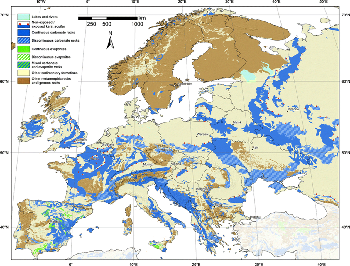
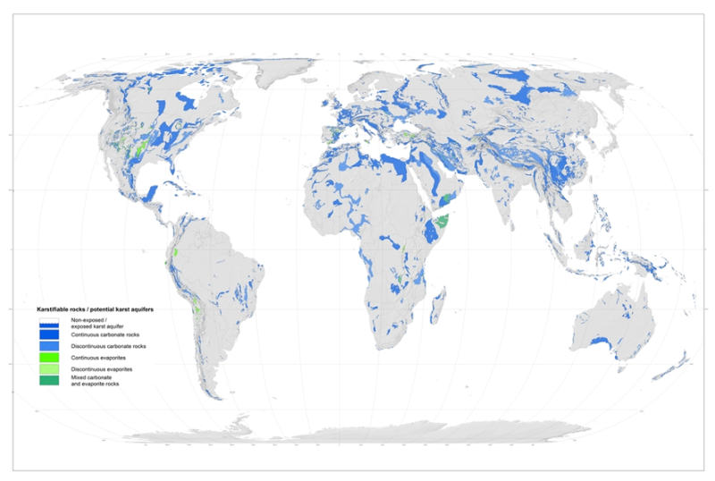
Karst is a landscape with distinctive hydrology and landforms that arise when the underlying rock is soluble. The vast majority of karst landforms are found on carbonate rocks, such as limestones. Karst landscapes typically are characterised by distinctive features including sinkholes, caves, enclosed depressions, disappearing streams, springs and sinkholes. Karst aquifers, which are karst rock that can provide drinking water, contribute substantially to freshwater supplies in many regions of the world. The World Karst Aquifer Mapping (WOKAM) project has created a world map and database of karst aquifers as shown below. You can see in the map below that over 20% of the European land surface is characterised by the presence of carbonate rocks and about 14% of the land surface is carbonate rock outcrop (rock is at the ground surface with no soil on top).


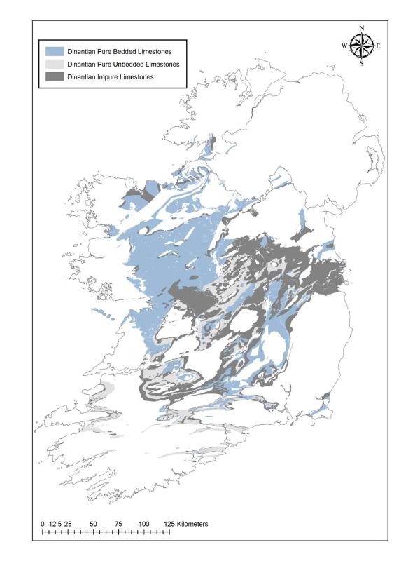
In Ireland we have a large proportion of carboniferous limestone rock present particularly across the midlands and the west of the country. Karst features have been located in nearly every part of Ireland meaning that most of our pure limestones have undergone some form of previous karstification. We have both upland (like the Burren) and low-lying areas of karst in Ireland (Gort lowlands).
Most karst landforms in Ireland are found in the West of Ireland. The nature of the limestone strongly influences its susceptibility to karstification. Pure bedded limestones are more susceptible to karstification and contain most karst landforms than impure (or mud or shale-rich) limestones.
The Main karst regions are:
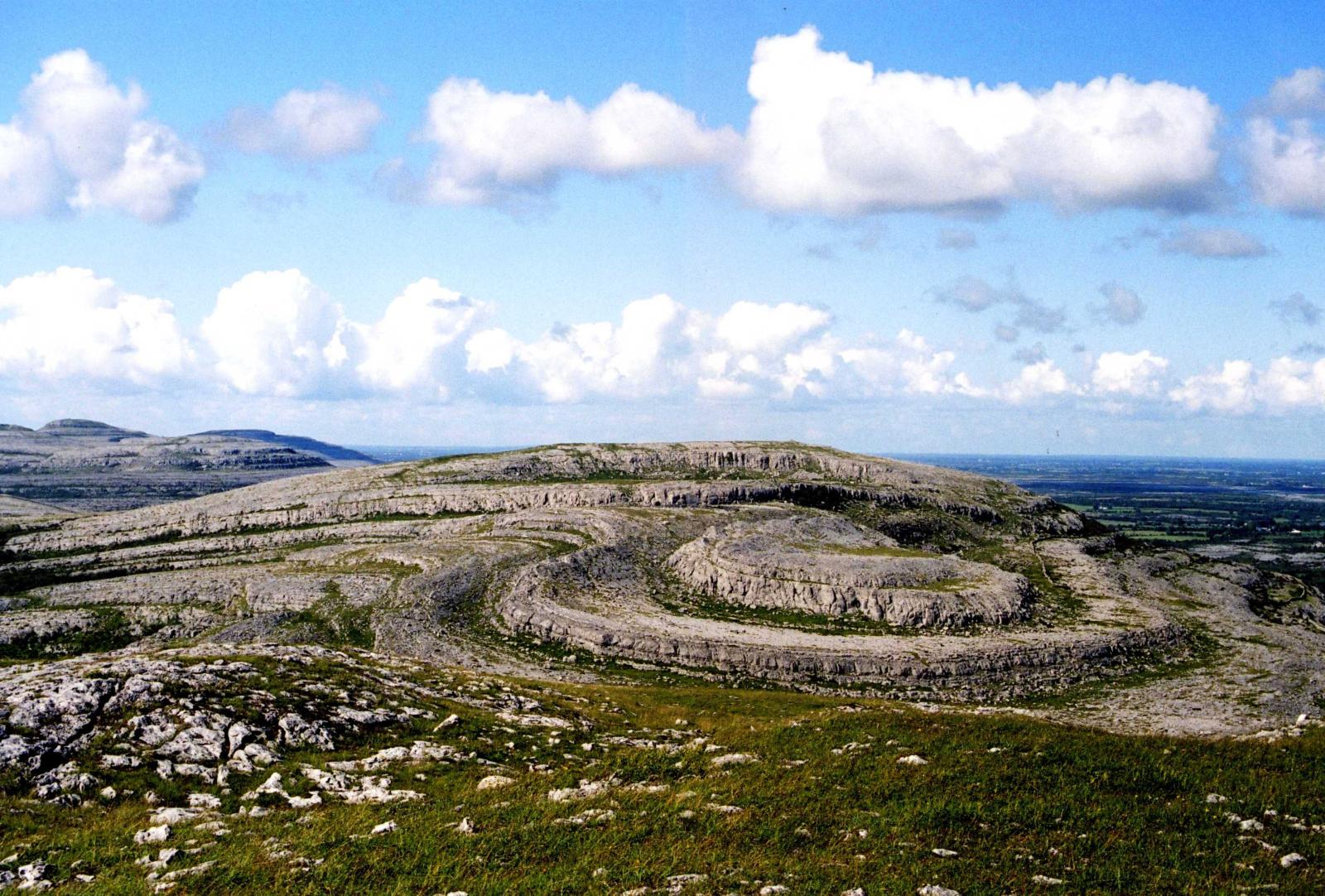
- The Burren Plateau
- Plateaux of the North-West
- The Western Lowlands
- The Eastern Lowlands
- Southern Valley Karst
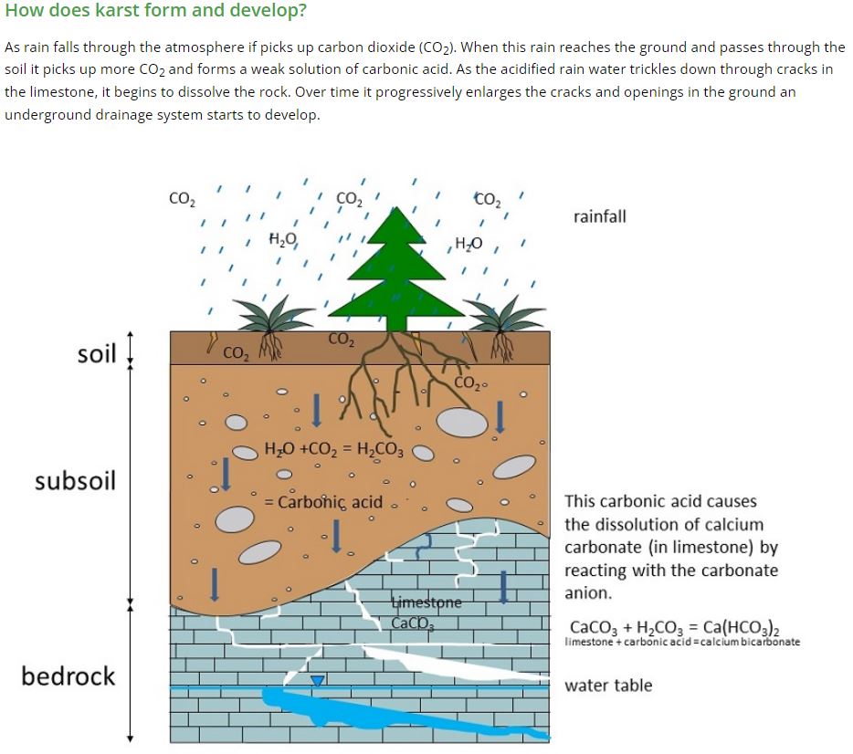
Carbonation
Carbonation is one of the most common forms of chemical weathering. Carbon dioxide is absorbed by rainwater as it falls. The rainwater passes through the soil absorbing more carbon dioxide which is released by organic matter. The rainwater and carbon dioxide combine forming a weak carbonic acid which causes a reaction with the calcium carbonate in limestone rocks. This reaction produces a solution called calcium bicarbonate. The solution slowly dissolves the limestone through the process of solution at its lines of weakness in the bedding planes and joints. Limestones with a high calcium carbonate content are known to display the best examples of karst features.
Chemical formula for calcium bicarbonate
Karst Landscape: The Chemical Weathering of Limestone Features
Diagrams of surface and underground Karst features
Source: Geological Survey of Ireland
Karst Landforms
Follow the interactive map below to explore the main karst landform features illustrated above in the diagrams.
Bedding planes
Bedding planes are widespread and very significant features within most carbonate rocks, and caves commonly develop along their orientation. A bedding plane is the surface that separates each successive layer of a stratified rock from its preceding layer. For carboniferous rocks in Ireland, these typically were formed by ancient oceans depositing media which eventually formed sedimentary rocks.
Limestone pavement
Exposed limestone is referred to as limestone pavement and our best example is located in the Burren, Co. Clare.
Caves
Caves in karst typically develop along bedding planes, faults or areas areas of weaker rock which dissolves more readily. Most caves in karst transmit water and the flow of water often scours the cave walls as can be seen in the images. The Ailwee cave is located in the Burren, Co Clare and is a great example of a karst cave feature.
Turloughs
Turloughs are temporary lakes usually filled by groundwater in karst limestone areas. Most flood in the autumn through the winter and early spring and then dry up between April and July. Shown here is Caherglassaun Turlough which is close to the Coole Park complex.
Springs
Springs occur in limestone where water flows out of the rock due to gravity (or head) and the spring can flow year round or can be seasonal depending on the location and groundwater table. Karst springs are a valuable source of drinking water in Ireland. A series of large springs drain water from the lowland karst of south east Galway at Kinvara as shown here.
Disappearing streams
Rivers and streams flowing on karst rocks can sometimes disappear into a swallow hole and enter the bedrock to either flow through caves, fractures or within the epikarst or shallow weathered karst bedrock. Shown here is where the Gort river disappears underground at Castletown sink. The river then re-emerges at Kiltartan shown at location 7
Re-emergence
A re-emergence is the point at which an underground stream reaches the surface and becomes a surface stream again. Here the Gort river (and others!) re-emerge at Kiltartan.
Swallow holes
A swallow hole is a natural depression or hole in the karst rock surface, also known as a sink or doline. It is caused by chemical dissolution of the carbonate rocks. Often streams or rivers can flow off the rock into a swallow hole. Shown here is a swallow hole at Lough Coy turlough during dry conditions.
Polje
A polje forms within an enclosed depression which is usually extensive and often elongated with a flat base and steep walls. Similar to a turlough, its base floods seasonally and drains to the karst bedrock.
Cave features
Various features can form during the chemical dissolution process that occurs in carbonate rock during karstification. These include: curtains, pillars, stalactites, stalagmites and straws. Images of some of these features are shown here many of which can be observed at one of the most famous karst caves in Ireland - the Ailwee cave in the Burren, Co Clare.
Karst hydrology
Karst hydrology can be very complex as water can be exchanged between the land surface and the bedrock in large volumes and the movement and exchange of water is often difficult to track and quantify. One of the most complex lowland karst hydrological systems is located in south-east Galway across the Gort lowlands. An overview schematic of the main rivers which flow from the upland mountainous area to the east onto the lowland karst on then on to the sea at Kinvara is shown below. Below ground flow of water in the karst bedrock is shown in red dashed lines whilst blue lines represent river flow above ground.
Overall flow of water through the Gort lowlands from the mountains
Geology & surface hydrology
The Slieve Aughty mountains are located to the east and are made up of Old Red Sandstone rock. Three river flow off these mountains onto the Limestone rock of the Gort lowlands and then disappear and reappear a number of times before draining to the sea at Kinvara completely underground though the bedrock - the last visible surface water feature before Kinavara is Cahermore turlough located almost 6km inland (just north of Caherglassaun in the map below). The geology, main rivers and turloughs in the Gort lowlands are shown in the map below.
Click on the button "Open in Map Viewer" on the map below or alternatively copy and paste the link below in a new tab.
Try turning on and off the bedrock geology and and karst feature map layers for the Gort lowlands.
https://arcg.is/050nH00
Owendallulagh River Route
Use the interactive map below to follow the complex path of the largest river flowing off the Slieve Aughty Mountains as it flows down onto the Gort lowlands and enters the karst limestone environment.
River source
The Owendallulagh River rises in the Slieve Aughty Mountains (near Derrybrien)
Lough Cutra
The river flows though Lough Cutra which is a relatively large lake covering almost 4km 2 and controls the flow of water downstream to the lowlands as water is slowed while it passes through the lake.
Devils punchbowl
The river flows out of Lough Cutra overground (as the Beagh River) as far as a large swallow hole known as the Devils Punchbowl. The Devils Punchbowl is a massive depression which is a collapsed karst feature. Here the river disappears underground into the limestone bedrock.
Blackwater Rising
The river briefly rises to the ground surface again at the Blackwater Rising approximately 150m to the south-west of the Devils Punchbowl.
Blackwater Sink
The river flows for short distance of approximately 150m before disappearing again into the bedrock at the Blackwater Sink
Pollduagh (Cannahowna) Cave - Gort River rising
The river flows out of a cave feature at the Pollduagh and flows overland again as the Gort River towards Gort town.
Karst swimming pools!
Big Hopes, Small Hopes and Sandies were old swimming pools / paddling areas used by local children years ago along the Gort River close to Gort town. These pools are actually referred to as ‘pots’ and are vertical "holes" in the bedrock which are connected to the groundwater table.
Castletown Sink
The Gort river flows out of Gort town as far as Castletown where it flows into the bedrock at the Castletown Sink.
Kiltartan Rising
The river combines with flow from two other rivers flowing off the Slieve Aughty Mountains and re-emerges to flow overland at the Kiltartan river rising
Kiltartan Sink
The river flows underground again at the Kiltartan sink and flows underneath the M18 motorway towards Coole Park.
Coole River Rising
The river remerges from the bedrock again in Coole Park as the Coole River and flows into Coole Turlough.
Coole turlough
Coole turlough is the largest turlough in the lowlands and is connected to a number of other smaller turloughs by the bedrock and overland during flood including, Garryland, Newtown, Hawkhill and Doo Lough.
Caherglassaun Turlough
Water flows out of the Coole-Garryland complex through numerous swallow holes into the bedrock towards the sea at Kinvara. It passes through Caherglassaun Turlough which is affected by the tide showing it direct connection to the sea.
Cahermore turlough
At high flood levels water also floods Cahermore turlough before draining to the sea at Kinvara. During a very extreme flood in 2016, water flowed overland from Cahermore turlough directly to the sea when an emergency channel was excavated to relieve persistent and dangerous floods.
Kinvara Springs
Water flows over 6 km from the last turloughs near Coole to a series of springs close to Dunguaire Castle in Kinvara.
What is a turlough?
A Turlough is temporary or seasonal lake that appears during the wettest time of the year in late Autumn or Winter and disappears again in late Spring. Turloughs can be fed either by rivers that drain to a swallow hole that backs up during high flow periods, or by the karst bedrock draining the surrounding area. Sometimes turloughs are filled from locations that are far away, where the bedrock allows water to rise up in low depressions like a surcharge tank. Because of their unusual environmental conditions, turloughs support very special ecosystems which are rich in plants and insects.
In some turloughs, there is a permanent pond or wetland in the middle. In the wintertime, when the water table rises, turloughs turn into lakes. They fill quickly – over a matter of hours or days – either from the inflowing river or usually from the bedrock itself. In the summertime when they are dry, they are typically grasslands, usually grazed by cattle.
Below are they animations of how the three main types of turloughs fill and empty.
River fed turlough draining to a swallow hole
Turlough fed by diffuse flow from the surrounding bedrock
Turlough fed by the bedrock deeper below usually transmitting water from a distant location
Cave Diving
In 2007 Polish diver Artur Kozlowski and Irish diver Tom Malone began cave diving in Ireland which is a unique and often dangerous challenge. They began diving in Kiltartan starting in early 2008, and in the face of winter floods and spring storms, the project was named the 'Riders on the Storm' traverse. Over a number of years and facing many obstacles and dangerous near misses, and with the help of many other divers, Arthur and another diver Jim Warny managed to successfully traverse the connection between Castletown and Kiltartan which they believed to be the longest traverse of water-filled underground caves in Ireland and Britain. It took 45 separate dive attempts to complete the traverses totaling 4km. The path of their traverse is marked on the map below and a cross-section of what they encountered is also shown.
Tragically, Artur Kozłowski died during a cave dive in the Gort lowlands on 5 September 2011 - he will always be remembered as an avid explorer and he contributed substantially to our understanding of the caves beneath the Gort lowlands.
Cave diving has also proved the connection pathway between the Blackwater sink and the Gort river rising at Pollduagh
Line shown in red is the route of the cave dive between the Blackwater sink and Pollduagh
The picture below is of a cave diver who is installing an instrument to measure the water level or "water head" at the Kiltartan river sink in 2020 as part of a GSI research project.


