Mapping 'Blue Carbon' in Cambodian Mangroves
A Case Study Analysis for the Koh Rong Archipelago
Introduction
Mangroves, are a group of intertidal shrubs and trees, that occur along the sub-tropical and tropical ocean coastlines of more than 120 countries. These coastal ecosystems provide a diverse range of goods to coastal communities as well as a wide array of ecosystem services such as shoreline protection and habitat provision.
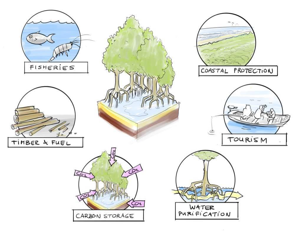
Illustration highlighting some of the ecosystem services mangroves provide. Illustration by Joost Fluitsma.
An ecosystem service of particular interest however, is the storage of blue carbon. Blue carbon refers to the carbon stored in mangroves and other coastal ecosystems. Coastal ecosystems are increasingly recognized worldwide for their role in climate change mitigation due to their significant potential for carbon storage and sequestration. These ecosystems, while only making up two percent of global area, are ten times more effective at sequestering carbon dioxide on an annual per area basis than boreal, temperate and tropical forests.
Unfortunately, despite the numerous benefits and services provided by mangrove forests and other coastal ecosystems, they are some of the most threatened ecosystems on earth. Their degradation is largely driven by direct and indirect human-induced factors such as deforestation, increasing coastal development, agriculture, aquaculture and the effects of climate change. When degraded, these ecosystems begin failing to act as carbon sinks and can ultimately become large sources of carbon emissions. In response to the negative effects of coastal ecosystem degradation, there is opportunity for the development of coastal blue carbon projects to conserve and restore these ecosystems using carbon financing mechanisms/programs. The logic behind carbon financing programs is that carbon stored in these coastal ecosystems can be quantified and sold as credits.
Cambodia, a Southeast Asian country with extensive mangroves, is a recognized hotspot for mangrove deforestation worldwide. Thus, Cambodia represents an ideal candidate for the adoption of mangrove conservation and restoration projects. In this study, a case study analysis for the Koh Rong archipelago in Cambodia was performed. This involved detecting the change in mangrove extent and blue carbon stock between 2009-2020, using satellite imagery from Landsat.
Geographic context for the Koh Rong Archipelago
Methods
To conduct a blue carbon assessment for the archipelago, mangrove extent needed to be quantified. To do this, satellite images were selected from 2009 and 2020 - giving a roughly 10-year time frame to conduct the study and determine long term trends. Mapping the distribution of mangroves required accurate distinction from the surrounding non-mangrove vegetation - to do this false colour composites and vegetation indices were utilized (see below).
The utilization of false colour composites and vegetation indices allowed for the collection of data that was representative of different land covers on the archipelago. For the sake of simplicity, three land cover classes were identified: Mangroves (class of interest), Other Vegetation and Developed. The developed class acted as an umbrella term to denote land covers that are indicative of human activity such as roads, houses and agricultural land. This data collection allowed for the creation of classified land cover maps for the archipelago, using the machine learning algorithm - Random Forest, for the years 2009 and 2020.
From the classified maps produced, land cover change detection and a Tier 1 blue carbon assessment could occur. Land cover change detection, involved comparing the classified maps from 2009 and 2020. This comparison allowed for the proportion of land conversion to be quantified.
In a Tier 1 blue carbon assessment, blue carbon estimates are calculated by simply multiplying the area of an ecosystem by the mean carbon stock for the given ecosystem type. This was completed by calculating the extent of mangroves from the 2009 and 2020 maps and multiplying them by the total carbon stock value for mangroves in Southern Cambodia. The results from each year were compared in order to determine trends in mangrove extent and blue carbon.
Tier 1 Blue Carbon Assessment = Mangrove Extent x Mangrove Carbon Stock Value
Results
Land Cover Classification Maps
Land cover classification maps were created for the Koh Rong Archipelago for the years 2009 and 2020. The overall accuracies of the 2009 and 2020 classified maps, using accuracy assessment metrics, were 95.7% and 96.1%, respectively.
Click and drag the slider in the middle to see how the Koh Rong Archipelago has changed between 2009 (left frame) and 2020 (right frame). An elevation mask was applied in order to reduce image extent based on mangrove habitat suitability. Elevations above 30m, seen in gray, were masked out before classification occurred.
Land Cover Change Detection
Between 2009 and 2020 there has been considerable expansion of the developed land cover class at the expense of the mangrove and other vegetation class. The developed class increased its extent by 183%. With the mangrove and other vegetation class declining by 20% and 43%, respectively.
Displays an alluvial diagram showing the proportion of land cover change (in hectares) between the three primary classes. As illustrated, one can observe the increase in the developed classes extent at the expense of the other classes.
Tier 1 Blue Carbon Assessment
Mangroves covered 202.41 hectares in 2009 and 166.23 hectares in 2020. Mangrove extent for each year was then converted into a blue carbon estimate, using the mean total ecosystem stock value for mangroves in Southern Cambodia of 386 MgC/ha (MgC = a tonne of carbon). Over the decal period, mangrove extent declined by 36.18 hectares, representing a total decline of 13,965 MgC across the archipelago.
Depicts changes in mangrove extent and carbon stock across the Koh Rong Archipelago.
Discussion
The decadal blue carbon assessment for the Koh Rong Archipelago found that mangroves declined by 36 hectares, or roughly 18% between 2009 and 2020. This decline in mangrove extent represents a total decline of 13,965 MgC in the region. This decline in mangrove extent and the negative impact on blue carbon was an expected result, as Cambodia is recognized as a hotspot for mangrove deforestation. However, it should be noted that Tier 1 blue carbon assessments, like the one conducted in this study, have a large associated error and can be further refined.
For one, international standards set out by the Intergovernmental Panel on Climate Change (IPCC) identify three tiers of detail in carbon stock inventories: Tiers 1-3, with higher order Tiers having increasing certainty and accuracy in their carbon stock estimates. In order to elevate the blue carbon assessment conducted, a field sampling regime must be undertaken in order to gain site-specific data with regards to the total carbon stock value for the mangroves of Koh Rong. This field data will allow the conduction of higher order assessment, resulting in more accurate blue carbon estimates for the region. Higher accuracy assessments are essential for quantifying the benefits of mangrove forests and their role in climate change.
A call to action! Image source: Mangrove Alliance


