Major Landforms of Wisconsin
These beautiful and remarkable landforms represent billions of years of geologic history—learn the stories behind them!

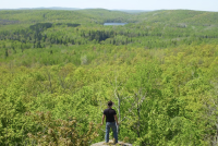
Gogebic and Trap Ranges
The Midcontinent Rift and the Dalles of the St. Croix
Blue Hills
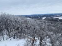
Margin of the Northern Ice Lobes
The Wisconsin Dells, Central Sands, and Glacial Lake Wisconsin
Baraboo Hills
Northern Highlands
Lower Wisconsin River Valley
Blue Mounds
Kettle Moraine
Green Bay and Fox River Lowland

Marginal Ridge of the Green Bay Lobe
Drumlins of the Southern Green Bay Lobe
Niagara Escarpment
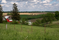
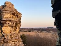
Driftless Area
Gogebic and Trap Ranges
The Gogebic and Trap ranges form two prominent parallel, northeast-southwest trending ridges in Iron and Ashland counties in northern Wisconsin. Both ridges are composed of rock types that are more resistant to erosion than the slate rock that underlies the valley separating the ridges. Glacial deposits from the last glacial cycle, approximately 20,000 years ago, cover the valley and parts of the ridges.
The southern ridge, the Gogebic Range, contains iron-rich rock that is approximately 1.9 billion years old; it was mined for iron ore beginning in the 1880s. Relatively soft iron ore was initially removed from shallow mines that have collapsed over time. In the 1920s, harder, high-grade "direct shipping" iron ore was mined from depths as great as 5,200 feet. This ore, which could be used in blast furnaces without further processing, was once a staple of the steel industry in the United States and drew many settlers to northern Wisconsin and the Upper Peninsula of Michigan. Although mining continues today in Minnesota and Michigan, the Wisconsin industry closed in 1964 due to ore depletion and production costs. The final iron ore shipment from Wisconsin left the Gogebic Range in 1965.
The northern ridge, known locally as the Trap Range, is distinctly different in composition from the Gogebic Range. It is composed of much a younger volcanic rock called basalt—sometimes referred to as traprock, hence its name—that is approximately 1.1 billion years old. Similar rocks are also exposed along parts of Lake Superior and the Saint Croix River and are present in the subsurface for nearly 1,200 miles as they gently arc from Lake Superior southwest to Minnesota, Iowa, Nebraska, and Kansas, and southeast to Ontario, Michigan, and Ohio. The northern ridge contains a segment of the North Country Scenic Trail and adjoins Copper Falls State Park .
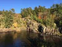
The Midcontinent Rift and the Dalles of the St. Croix
The Saint Croix River—a National Wild and Scenic River—marks part of the present-day boundary between Wisconsin and Minnesota.
A portion of the river cuts through a dark gray-green volcanic rock called basalt that dates to the failed rifting of North America. Approximately 1.1 billion years ago, the Earth’s crust began splitting apart along a rift axis from modern day Lake Superior to Kansas, with enormous volumes of volcanic rocks erupting to the surface. Known as a midcontinent rift, the process left a large area of the Upper Midwest covered in volcanic deposits. Ultimately, the rift failed to separate North America into separate continents, but it left behind a spectacular geologic signature. The towering vertical basalt walls known as the Dalles can be seen at Saint Croix Falls today.
Notably, the modern Saint Croix River is far too small to have cut through the hard basalt that forms the Dalles. The formation of the Dalles dates to the end of the last glacial cycle, approximately 20,000 years ago when vast volumes of meltwater were being released from the Laurentide Ice Sheet . As the ice sheet retreated, meltwater pooled in the western part of the Lake Superior basin, forming what is known as glacial Lake Duluth. Glacial Lake Duluth had a significantly higher lake level than the modern Lake Superior, and consequently overflowed through the Bois-Brule spillway (that you can see at the Brule Glacial Spillway State Natural Area) into the Saint Croix River drainage. The immense volumes and velocity of water at that time would far surpass the discharge of today’s Saint Croix River and are responsible for cutting the Dalles of the Saint Croix River.
The nearby Interstate State Park along the Saint Croix River is renowned for its 'potholes,' which are similar in glacial origin to the Dalles. The fast-flowing water flooding out of glacial Lake Duluth would, in places, scour small depressions into the surface of the basalt bedrock. As depressions deepened over time, boulders would sometimes be washed into them. The turbulent water would have enough energy to rotate the boulders in these deepening holes, causing them to grind downward and create vertical potholes in the basalt—some as deep as 60 feet! Interstate State Park is the western terminus of the Ice Age Trail , a national scenic trail that traces the footprint of the Laurentide Ice Sheet across Wisconsin.
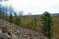
Blue Hills
The Blue Hills rise about 600 feet above the landscape of northwestern Rusk, southwestern Sawyer, and northeastern Barron counties. The hills are formed from erosion-resistant red quartzite that is topped with a thin layer of glacial deposits. The quartzite is composed of sand from a river or a beach that existed approximately 1.5 billion years ago. The sand was first transformed into sandstone, and then later underwent more heat and pressure to be transformed into quartzite through metamorphism. Quartzite owes its name to its composition of quartz-rich (i.e. composed entirely of silica) sand, which is extremely durable and resistant to weathering over time. It is similar in age and appearance to the quartzite that forms the Baraboo Hills and several other prominent uplands in Wisconsin, Minnesota, and South Dakota. Some of these quartzite localities contain beds of metamorphosed mudstones called catlinite, or pipestone, a soft rock that is still quarried and carved into pipes and effigies by Native Americans today.
Contained within several small valleys on the southwest side of the Blue Hills is a felsenmeer , or a 'sea of rocks.' This unique feature consists entirely of fractured boulders of the quartzite bedrock. During the peak of the last glaciation, approximately 26,000 years ago, this area was not covered by the ice sheet, but situated only a few miles from it. The ice age climate was much colder than today and the landscape would have undergone a severe freeze-thaw cycle, which resulted in the boulder-strewn area. The valleys at Blue Hills are similar to the quartzite talus slopes at Devils Lake farther south in the state. Cold air emanates from under the slopes, providing habitat for several boreal and tundra plant species.
Margin of the Northern Ice Lobes
Evidence of the repeated continental glaciation in Wisconsin during the last 2.6 million years, a period called the Pleistocene Epoch, is best illustrated by the beautiful landforms developed particularly along the edges of the glacial ice maximum extent.
The maximum extent of the Chippewa, Wisconsin Valley, and Langlade lobes of the Laurentide Ice Sheet in northern Wisconsin occurred approximately 20,000 years ago. The outer edge of each glacial lobe is clearly marked in many places by narrow, sharp-crested ridges called moraines and a broad (up to 6 miles wide) band of uneven ground called hummocky topography. This hummocky area features many poorly drained, bowl-shaped depressions called kettles that commonly contain wetlands or lakes. The formation of kettles was a result of large ice slabs that became detached from the margin of the melting glacier and were then buried by glacial and meltwater sediment. Later melting of this buried ice resulted in the uneven collapse of the overlying sediment and the development of hummocky topography, including kettles. A good location to visit this hummocky area is Mondeux Hardwoods in Taylor County.
The terminal margin of the Laurentide Ice Sheet is visible in Langlade, Lincoln, and Taylor Counties. The rock-strewn and hummocky landscape of this glaciated area is noticeably different from the rolling topography of the area to the south. As a result, the glacial boundary here is also a boundary between farmland to the south and forest to the north. The Ice Age Trail follows the margin of the ice sheet in this region.
The Wisconsin Dells, Central Sands, and Glacial Lake Wisconsin
During the most recent glaciation, part of the Green Bay Lobe (a lobe of the Laurentide Ice Sheet that advanced into eastern WI) intersected and overran the east end of the Baraboo Hills. It blocked the Wisconsin River, which flowed south (as it does today) around the east end of the range. When ice blocked the gorge in Devil’s Lake State Park approximately 26,000 years ago, it completely dammed the Wisconsin River. Water then rose to form glacial Lake Wisconsin, which occupied roughly 1,700 square miles of land north of the Baraboo Hills. The lake level eventually stabilized when water spilled westward into the East Fork of the Black River and began draining into the Mississippi River. The whole while, sediments eroded by the enormous Green Bay Lobe settled to the bottom of the new lake basin, creating the broad, sandy plains of central Wisconsin that we see today.
Glacial Lake Wisconsin remained stable until ice from the Green Bay Lobe began retreating in response to a warming climate. When the glacier ice retreated to the eastern tip of the Baraboo Hills approximately 17,400 years ago, the ice dam blocking the Wisconsin River failed catastrophically. The entire volume of the lake drained down the lower valley of the Wisconsin River in a massive flood. It has been estimated that the lake likely drained in as little as a week, and that the peak volume of flood waters in the lower Wisconsin River valley was roughly 20 times larger than the largest modern flood measured on the river. It is this catastrophic flood that carved the world-renowned Wisconsin Dells in the soft layers of sandstone exposed near the lake bed just upstream from where the ice dam failed. The floodwaters also swept huge boulders and icebergs many miles downstream.
The broad, flat, sandy bottom of glacial Lake Wisconsin is today known as the Central Sand Plain, which is home to forested areas, wetlands, and the majority of Wisconsin’s potato and cranberry industries. Along with large boulders, massive volumes of sand and gravel were discharged along the margin of the Green Bay Lobe, deeply burying much of the pre-existing landscape across central Wisconsin. Only isolated pinnacles, such as those at Roche-a-Cri State Park and Camp Douglas , stand above the ancient lake floor. In some areas, as much as 300–400 feet of sand and gravel were deposited between approximately 31,000 and 17,400 years ago.
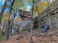
Baraboo Hills
The Baraboo Hills, which form an elongated horseshoe in Sauk and Columbia Counties trending approximately east-west, rise nearly 700 feet above the surrounding landscape. The hills are composed of distinctive purple-red rocks called quartzite, which is extremely durable and resistant to erosion. The Baraboo Quartzite formed approximately 1.5 billion years ago, when a sandstone formation underwent metamorphism and was folded and uplifted to create a small mountain range. At the base of the Baraboo Hills, below the resistant quartzite layer, there are many isolated exposures of even older rocks, including granite and some volcanic rocks. During the maximum extent of the most recent glaciation in this area, approximately 25,000 years ago, the Green Bay Lobe of the Laurentide Ice Sheet surrounded the eastern half of the hills. It created ridges, i.e. moraines, that blocked each end of an ancient valley that now contains Devils Lake. Today, the Baraboo Hills are one of the largest forested areas in southern Wisconsin and home to Devil’s Lake State Park .
Northern Highlands
The Northern Highlands contain the highest elevations in Wisconsin and is composed of some of the oldest rocks in North America, called the Canadian Shield. These rocks were formed, deformed, and uplifted into mountains multiple times, over 1 billion years ago during the Precambrian Era. After these rocks were formed, they were likely mountain peaks standing above ancient oceans, eroding and generating the sediments that form the bedrock of southern Wisconsin. Subsequently, numerous glacial cycles during the last 2.6 million years covered the bedrock of the Northern Highlands with a veneer of glacial sediments.
Today, the Northern Highlands area of Wisconsin is widely known for its forests, lakes, and wetlands. Most of these lakes and wetlands occupy kettles and broad plains formed by rivers carrying meltwater and sediment, called outwash, associated with the Langlade, Wisconsin Valley, and Chippewa lobes of the Laurentide Ice Sheet as it receded from its maximum extent about 20,000 years ago.
This area also features the highest point in Wisconsin. Timms Hill , a thick accumulation of glacial debris in Price County, rises approximately 1,952 feet above sea level.
Lower Wisconsin River Valley
The broad valley along this stretch of the Wisconsin River was eroded over several million years like the rest of the Driftless Area. The early development of the valley likely occurred in response to an eastward-flowing river that sent regional runoff towards the Green Bay lowland. During the numerous glacial cycles that occurred over the past 2.6 million years, that river reversed course and joined with the Mississippi River as drainage in the upper Midwest shifted toward the Gulf of Mexico. The Lower Wisconsin River valley and Mississippi River valley then proceeded to cut deeply into the underlying bedrock. During the most recent glacial cycle (some 50,000 to 15,000 years ago), meltwater from the Laurentide Ice Sheet deposited sand and gravel (in places over 200 ft thick) in both valleys to create the broad, flat valley bottoms seen today. Because the lower Wisconsin River valley was carved deeply into bedrock and then subsequently filled with sand and gravel, the modern valley is characterized by vertical bedrock bluffs along its length.
Early in the history of North American colonization, the lower section of the Wisconsin River was part of the water route for trade and exploration from the Great Lakes to the upper Mississippi River. People could travel by boat from Green Bay up the northeastward flowing Fox River to the present site of the aptly-named city of Portage. At this location, boats were portaged—carried overland—approximately 2 miles across the drainage divide into the Wisconsin River, which flows into the Mississippi River near the city of Prairie du Chien.
Blue Mounds
The Blue Mounds are two prominent bedrock hills in the Driftless Area near the border of Dane and Iowa Counties. They are the highest points on the landscape in southern Wisconsin—300 to 500 feet above the already elevated Military Ridge on which they sit, and about 1,000 ft above the Lower Wisconsin River just to the north. Both mounds contain broad platforms of Ordovician shale, formed approximately 450 million years ago. The west mound towers above its counterpart to the east because it is capped by an approximately 100-foot-thick layer of silicified, chert-bearing Silurian dolomite that was deposited approximately 440 million years ago and is extremely hard and resistant to erosion. East Blue Mound has lost this resistant layer over the eons, with only scattered boulders remaining of its dolomite cap. Layers of this resistant, younger dolomite once covered southern Wisconsin, but this layer was eroded from all but the tops of these and several other mounds in far southwestern Wisconsin. Chert, like that found at Blue Mounds, was used by Native Americans to make arrowheads and tools that are found in the many archaeological sites in the area.
Kettle Moraine
The Kettle Moraine is a belt of irregular ridges and upland areas that extends for more than 120 miles, primarily in Sheboygan, Washington, and Waukesha Counties. Landforms in the Kettle Moraine area were deposited at the intersection of the Green Bay and Lake Michigan Lobes as they receded from their maximum southerly positions during the last glacial cycle, approximately 18,000 to 15,000 years ago. This "interlobate" area includes some spectacular examples of classic glacial landforms, including kettles, kames, eskers, moraine ridges, outwash plains, and small meltwater lake plains.
Kettles are pot-shaped depressions formed when large blocks of buried ice melted after the ice lobes receded. Other common landforms in this region include kames, which are conical hills of gravel deposited when meltwater is funneled through cracks in the glacier, and eskers, which are ridges of sand and gravel that formed from rivers flowing through the glacier. Large parts of the Kettle Moraine have been preserved in the Kettle Moraine State Forest . The sand and gravel that makes up these landforms is sometimes mined for construction purposes.
Green Bay and Fox River Lowland
The conspicuous, broad area of eastern Wisconsin that slopes toward Green Bay and the Fox River reflects the underlying sedimentary bedrock, smoothed and worn by glaciers. The surface that slopes into the bay is broken by north–south trending ridges, which are glacial moraines. The flat area extending to the west and south of Lake Winnebago once was part of glacial Lake Oshkosh. The lake filled a large part of the lowland with meltwater from the Green Bay Lobe of the Laurentide Ice Sheet as it advanced and later receded.
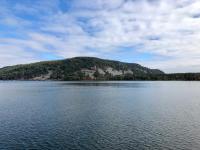
Lake Winnebago, the largest lake in the state, is bound on its eastern margin by an escarpment of erosion-resistant dolomite known as the Niagara Escarpment. The escarpment, which provides spectacular views over Lake Winnebago, extends northward and forms the Door Peninsula. The dolomite layers dip eastward toward Lake Michigan and are a source of crushed stone and building material in the region.
Marginal Ridge of the Green Bay Lobe
The marginal ridges or moraines of the west side of the Green Bay Lobe are a result of the accumulation of sediment transported by the glacier. These marginal north–south trending moraines are especially visible in Marathon, Portage, and Waushara counties. As the Green Bay Lobe melted back into the Green Bay and Fox River lowland, it paused at several positions due to periods of cold temperatures, forming smaller yet distinct moraines that are especially noticeable in Shawano, Marinette, Menominee, and northwest Oconto counties.
The Johnstown Moraine marks the farthest westward extent of the ice of the Green Bay Lobe during the height of the most recent glaciation approximately 20,000 years ago. This ridge is most apparent at the Baraboo Hills, extends along the east side of the Central Sand Plains, and continues north. It also continues south and east from Baraboo, through Johnstown in Rock County, marking the southern edge of the glacier’s advance during the late Wisconsin glaciation. An older remnant moraine, the Arnott, is partially preserved west of the Johnstown Moraine in Portage and Waushara counties. This marks an earlier maximum extent of the Laurentide Ice Sheet that was deposited between 50,000 and 30,000 years ago.
Drumlins of the Southern Green Bay Lobe
In the central to southeastern part of the state (particularly Dane, Dodge, and Jefferson counties), glacial landforms known as drumlins dominate the landscape. These formed beneath the moving ice of the Green Bay Lobe, between about 20,000 and 15,000 years ago. The drumlins are elongated hills up to a mile long that point in the direction of ice flow, which was generally to the south and west in southeastern Wisconsin.
Drumlins can be made of bedrock or glacial sediments, and many drumlins in Wisconsin are composed of sand and gravel. This sand and gravel is sometimes mined for the purpose of construction. Poorly drained, low-lying areas between drumlins may be occupied by wetlands; some higher, drier areas may be covered by prairie. The drumlins of the Green Bay Lobe are among the best preserved in the world. One good spot to visit and view drumlins is at Horicon Marsh in Dodge County. Drumlins can also be seen in many other areas of Wisconsin that were once glaciated.
Fun Fact: The State Capitol in Madison rests atop a drumlin.
Niagara Escarpment
The Niagara Escarpment is a long cliff that stretches in a wide arc from eastern Wisconsin through Michigan’s Upper Peninsula, across Ontario, Canada, and on through the Niagara Falls in New York. The rock forming the escarpment—dolomite—was originally deposited as lime mud on an ancient sea floor that stretched across Wisconsin approximately 430 million years ago during the Silurian Period. What remains is the result of uplift, weathering, and erosion of overlying rocks. In Wisconsin, the Niagara Escarpment is most prominent along the east side of Lake Winnebago and forms the high cliffs along the shore of Green Bay in Door County.
The escarpment is home to over 240 rare, threatened, or endangered plant and animal species, including white cedar trees that are more than 1,000 years old. It is also an important source of groundwater recharge. Natural cracks in the rocks and the thin layer of soil covering those rocks, however, leave the groundwater very vulnerable to contaminants.
See the special edition volume of Geoscience Wisconsin to learn more about the Niagara Escarpment. Ledge Park in Dodge County is one of many parks that lie along the Niagara Escarpment.
Driftless Area
The Driftless Area is the portion of the upper Midwest that was never covered by glacial ice during any of the glacial cycles over the past approximately 2.6 million years. The term Driftless is derived from the word 'drift,' which was the term for glacial sediment that was in use during the latter part of the 19th century.
This region, which covers southwestern Wisconsin and a small portion of northwestern Illinois, is marked by a complex pattern of branching river and stream valleys cut into nearly flat-lying layers of sandstone and dolomite that were deposited during the Cambrian and Ordovician Periods between approximately 500 and 450 million years ago. The branching, or dendritic, pattern of the valleys is characteristic of a landscape formed exclusively by stream erosion rather than glacial processes. Upland surfaces in the Driftless Area are topped by a layer of windblown silt, known as loess, that was deposited during the last glacial cycle. The loess is as much as 40 feet thick near its source, the Mississippi River valley, and progressively thins eastward. The steep valley-wall slopes in the region often have a few feet or less of soil and sediment covering them. The layers of sandstone and dolomite bedrock that the rivers and streams have cut into are exposed far better in this region than anywhere in the glaciated portions of the state. Valley bottoms are often filled with 10s to 100 or more feet of sediment that provides unique insight for scientists into the evolution of the Driftless Area.
The combination of near-surface sedimentary bedrock and deep incision into it by rivers has produced a wealth of landforms and ecosystems that are particular to the Driftless Area. The dolomite bedrock, which is a chemical variant of limestone, is soluble in this region and forms sinkholes, caves, and related karst topography . One example is the popular tourist attraction Cave of the Mounds , which formed in dolomite on the south side of East Blue Mound. Freshwater springs dot the hillslopes and feed the coldwater streams that make the Driftless Area one of the preeminent trout habitats in all of North America. Steep boulder fields, known as algific talus slopes, produce cool micro-climates that sustain numerous rare and endangered species of plants and animals that are holdovers from the last glacial cycle. This evocative landscape and its myriad features have, over the past several decades, given rise to a thriving ecotourism economy in the region.