Topographic Maps
8th Grade Lesson - TEK 8.9(C)
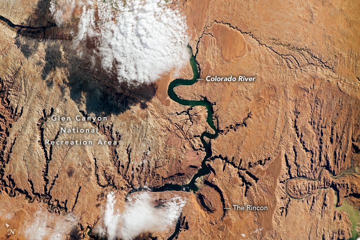
The Glen Canyon National Recreation Area in both Utah and Arizona. About five million years ago, the river began carving into these sedimentary rocks, exposing bedrock that dates back approximately 300 million years.
What To Do:
- On your answer sheet fill in the See-Think-Wonder section.
- Share with your group.

Answer Sheet
What are Topographic maps?
Most maps show a view of Earth from directly above. Some maps show streets and other show borders between towns, counties and states. A topographic map shows the elevation, or height above sea level, of natural features of a region. On a topographic map, features are represented using lines and symbols. The most important function of a topographic map is to show elevation. Lines on a topographic map that connect areas with the same elevation are called contour lines. Topographic maps display three-dimensional features of the land on a flat map.
Topographic Rules
What To Do:
- Using the slides from above list the 5 rules on your answer sheet .
The Glen Canyon National Recreation Area, Utah, US
What To Do:
- Find the Little Rockies on the interactive map to the right.
- With the + sign, zoom in three times.
- Find Freds Ridge near the Little Rockies, zoom in two times.
- What is the elevation of Freds Ridge?
- Record your response on your answer sheet .
NEED HELP? Follow the guide in the slides below.
Click the side arrows to navigate the (3) slides.
Hill County
Texas, US
What To Do:
- Find the Dallas- Fort W on the interactive map to the right.
- With the + sign, zoom in three times.
- Find Joe Pool Lake near Arlington, zoom in two times.
- What is the lowest elevation of Cedar Ridge Preserve?
- What is the highest elevation of Cedar Ridge Preserve?
- Record your response on your answer sheet .
Grand Canyon
Arizona, US
What To Do:
- Find the Nankoweap Creek on the interactive map to the right.
- With the + sign, zoom in one time.
- Find Mount Hayden near the Nankoweap canyon, zoom in three times.
- What is the highest elevation of Mount Hayden?
- Record your response on your answer sheet .
Oachita Mountains
Wester Arkansas, US
What To Do:
- Find the Walnut Mountain on the interactive map to the right.
- With the + sign, zoom in three time.
- Find Little Cow Mountain near Little Cow Creek , zoom in three times.
- What is the highest elevation of Little Cow Mountain?
- Record your response on your answer sheet .
What To Do:
- Look at the Little Cow Creek in the picture above.
- What can you tell me about the stream? (is it running, north to south, or south to north)
- How do you know? (look back at topographic Rule #3)
- Record your response on your answer sheet .
Mount Saint Helens
Washington, US
What To Do:
- Find Mount St Helens on the interactive map to the right.
- With the + sign, zoom in four time.
- What is the elevation of The center of Mount St Helen?
- Record your response on your answer sheet .
Mauna Loa Volcano
Hawaii , US
Current Event:
What To Do:
- Find Mauna Forest Reserve on the interactive map to the right.
- With the + sign, zoom in four time.
- Find Puu Makanako, near Mauna Kea
- Zoom in once.
- What is the elevation of The center of Puu Makanao?
- What do the lines on the circle represent? (look back at topographic Rule #3)
- Record your response on your answer sheet .
Mount Everest
borders of China and Nepal
What To Do:
- Find the Mt Everest on the interactive map to the right.
- With the + sign, zoom in two times.
- What is the highest elevation of Mount Everest?
- Record your response on your answer sheet .
Karakoram
borders of Pakistan, China, and India
Karakoram Mountain Range
Hispar Glacier
What To Do:
- Zoom out of the Hispar Glacier.
- It is located within the Karakoram Mountain Range.
- Do you think Glaciers have an impact on elevation? Why or Why not?
- Record your response on your answer sheet .
Japan
What To Do:
- Zoom in once and towards the south look for Fuji-Shi on the interactive map to the right.
- With the + sign, zoom in four times.
- Near Fuji-Shi, to the right, you will find Mt. Ashitaka and Mt. Echizen.
- Which Mountain has the highest elevation Mt. Echizen or Mt. Ashitaka?
- Record your response on your answer sheet .
Pico De Orizaba
What To Do:
- Find Pico De Orizaba on the interactive map to the right.
- With the - sign, zoom eleven out.
- What is the elevation of Pico De Orizaba?
- What country is the Pico de Orizaba located in? (zoom out)
- Record your response on your answer sheet .
Practice
What To Do:
- Write the letter and number of the profile that matches the topographic map in the box.
- Work with your small group.
- Record your responses on your answer sheet .
Topography and Satellites
Topography refers to the steepness or flatness of the land. Topography includes features such as mountains, hills, cliffs, valleys, and depressions. The processes of weathering, erosion, and deposition can change the topography of an area over time. For example, winds and gravity can lower the elevations of mountains by breaking them down and carrying away their rocks. Flowing rivers and moving glaciers can also cut canyons into the ground.
Scientists can track these changes in topography over time using satellite technology. Satellites are man made instruments that are launched into space and that orbit Earth. Many satellites are equipped with powerful cameras. These cameras can photograph landforms and other features from space. This provides a large-scale view of the topography of an area, which allows scientists to study major features and patterns in ways that would otherwise be impossible. Because satellites orbit Earth, they can photograph the same area every time they pass over it. This allows scientists to study the changes in topography that weathering, erosion, and deposition can make over time.
What To Do:
- Look at the image on the right.
- How might weathering, erosion, and deposition have caused this changes?
- Record your response on your answer sheet .


