Wetland Centre at Evergreen Park
A Virtual Tour of the Wetlands of Evergreen Park
A Story Map by:

Evergreen Park
Evergreen Park is located in northwestern Alberta in the County of Grande Prairie. Evergreen Park is situated in the Boreal Plains Ecozone and is within the Mighty Peace Watershed.
Evergreen Park
The County of Grande Prairie is part of the Parkland ecozone; however, it is surrounded by boreal forest and numerous boreal wetland types are represented at Evergreen Park.
The county is home to a wide range of industry activities including oil and gas, forestry, utilities, and agriculture.
Click or hover on points or areas of interest found at Evergreen Park.
Use the controls in the bottom right corner to zoom in and out or return to the original view (home).
Click the arrows in the top right to expand or minimize the map view, and use your mouse to move around the map.
Value of Alberta’s Wetlands
Wetlands are abundant across Alberta and cover and nearly 30% of the Mighty Peace Watershed (Mighty Peace Watershed Alliance State of the Watershed report 2015).
Wetlands in northern Alberta often form large complexes, the map on the right shows wetlands (blue) and uplands (grey) from Ducks Unlimited Canada's Enhanced Wetland Classification.
Wetlands are incredibly valuable ecosystems that provide important benefits both locally and globally. The wetlands at Evergreen Park support a range of ecosystem services including:
•Flood and drought mitigation by storing and slowly releasing water
•Water filtration and groundwater recharge
•Carbon storage and sequestration to help regulate the climate
•Highly productive ecosystems supporting a rich array of biodiversity
•Species of cultural importance to local communities
•Recreational opportunities
What is a wetland?
"Land saturated with water long enough to promote formation of water altered soils, growth of water tolerant vegetation, and various kinds of biological activity that are adapted to a wet environment." - Alberta Wetland Policy 2013
Wetlands can range from shallow open waters to treed systems. This diversity supports a range of ecosystem services, but can also make wetland identification and classification challenging.
Wetlands of Northern Alberta
Much of northern Alberta is part of the Boreal Plains ecozone. As part of wetland mapping efforts across Canada’s Boreal Plains, Ducks Unlimited Canada (DUC) has developed an Enhanced Wetland Classification (EWC) system sorting wetlands into five major and 19 minor wetland classes.
The DUC EWC closely aligns with the Alberta Wetland Classification System and both systems align with the Canadian Wetland Classification at the five major class level.
This story map focuses on the four major wetland classes found at Evergreen Park – fens, swamps, shallow open waters, and marshes. There are no bogs at Evergreen Park.
Wetlands of Evergreen Park
Wetlands and uplands are interspersed throughout Evergreen Park
Between 2016 and 2019 DUC mapped wetlands at Evergreen Park using a combination of remote sensing and field techniques.
This process unveiled a range of wetland types encompassing four of the five major wetland classes and several minor wetland classes.
Explore the mapped wetlands at Evergreen Park. Boreal Wetlands are grouped into two categories - peatlands (bogs and fens) and mineral wetlands (swamps, marshes, and shallow open water). Examples of both peatlands and mineral wetlands are found at Evergreen Park.
Click or hover on the button in the bottom left corner of the map to view the legend of wetland types found at Evergreen Park.
Use the controls in the bottom right corner to zoom in and out or return to the original view (home).
Click the arrows in the top right to expand or minimize the map view, and use your mouse to move around the map.
Peatlands
Bogs and Fens
•Characterized by poorly decomposed organic soil (peat) deposits more than 40 cm deep.
•Deposits build up slowly due to wet, cool, oxygen-deprived conditions.
•Peat is composed of partially decomposed mosses, herbaceous plants and woody debris.
•Tend to have permanently saturated soil and relatively stable water tables.
•Only fens, not bogs, are found at Evergreen Park.
Fens
•There are three forms of fen – wooded coniferous, shrubby, and graminoid – which are further broken down into rich and poor (e.g., graminoid poor fen, treed rich fen).
•Fens have greater than 40cm of poorly decomposed (moss and sedge peat) organic soil.
•Water inputs from precipitation and mineral-rich surface and ground water.
•Maintain a consistently high water table.
•Slow moving flow, including both surface and subsurface water.
•Two of these forms, shrubby and graminoid, are found at Evergreen Park.
Fen 'Richness'
In the DUC EWC system, fens are grouped into poor and rich fens. The categories and cut-offs may vary by classification system. For example, the Alberta Wetland Classification System groups fens into poor, moderate-rich, and extreme-rich.
Fens at the ‘poor’ end of the spectrum tend to have less ground-water inputs, resulting in less nutrients, lower pH (compared to rich fens), lower productivity, and less species diversity.
Fens at the ‘rich’ end of the spectrum tend to have more ground-water connections, resulting in more nutrients, higher pH (compared to poor fens), higher productivity, and more species diversity.
The fens at Evergreen Park are rich.
Fen Landscape View
Explore the 360 view of shrubby rich fens and graminoid rich fens at Evergreen Park in the photograph to the right.
Graminoid Rich Fens
•Tree and shrub cover is less than 25%, meaning that vegetation is low-lying and can be easy to traverse during the frozen season.
•The dominant ground cover is made up of fen species including Sphagnum spp. moss and brown mosses.
•The water table is typically at or near the surface.
•Graminoid fens are the dominant wetland type within the Wetland Centre MOU area and are also found in other areas of Evergreen Park.
Characteristic Species: Buck Bean
•Buck-bean (Menyathes trifoliata) is found in graminoid rich fens.
•Buck-bean is an abundant and easily identifiable species in Evergreen Park’s graminoid fens.
•It is an aquatic to emergent spreading species
•White flowers clustered at tip of a long stem with five white, hairy petals.
Graminoid rich fens can look quite different depending on the time of year and whether precipitation was higher, lower, or average. Below are graminoid fens at Evergreen Park through winter (top left), spring (top right), summer (bottom left) and fall (bottom right). These four photos were taken in different years; however, annual variations in precipitation can lead to some very noticeable changes.
The photo on the left was taken in September 2019 after a very wet and cool summer. The photo on the right was taken in September 2016 after a drier summer.
Shrubby Rich Fens
•Tree cover is less than 25%, shrub cover is more than 25% with shrubs typically 1-2m tall.
•Sphagnum spp. mosses are less than 20% of the area with a high diversity of plant species. Shrubby rich fens at Evergreen Park are dominated by bog birch.
•Water table is typically less than 10cm below the ground surface.
•Shrubby rich fens are found throughout Evergreen Park at the transition between graminoid rich fens and swamps.
Characteristic Species: Bog Birch
Bog birch (Betula gladulosa) is found in shrubby rich fens.
Bog birch is an erect shrub up to 2m tall with reddish brown twigs covered with large, warty glands.
The shrubby rich fens below through winter (top left), spring (top right), summer (bottom left) and fall (bottom right). Vegetation changes are evident, but surface water changes are less visible compared to the same time series in graminoid fens.
Treed Rich Fen
•Characterized by tree cover more than 25%, with a mix of black spruce and tamarack.
•Tamarack is more dominant in richer sites, such as those at the Evergreen Centre.
•Water table is typically less than 20cm below the ground surface.
•Treed rich fens are only found at the Evergreen Centre site.
Characteristic Species: Black Spruce
Black spruce (Picea mariana) is a small and slow growing coniferous tree with characteristic clump of branches towards the top of its crown.
Branches are whorled, lowermost sloping steeply downwards.
Seed cones are small (1-2.5 cm), oval and often purple in colour.
*Black spruce photos were not taken at Evergreen Park
Mineral Wetlands
Swamps, Marshes, and Shallow Open Waters
•Characterized by shallow organic deposits typically less than 40cm deep.
•Some mineral wetlands have organic soils with highly decomposed plant materials.
•Tend to have naturally fluctuating water levels, with water tables near, at, or above the surface for variable periods during the year.
•Water level fluctuations increase decomposition rates, influence water chemistry, nutrient availability and plant community structure and composition, giving rise to a number of wetland types.
•At Evergreen Park, many mineral wetlands have greater than 40cm of organic soil.
Swamps
•In DUC’s EWC system there are five minor swamp classes – tamarack, conifer, hardwood, mixedwood, and shrubby.
•Have a variety of water inputs (precipitation, surface water, groundwater) and are typically more nutrient-rich than peatlands.
•Fluctuating water levels cause temporary to seasonal flooding.
•Commonly found in transitional areas between wetlands and uplands, at Evergreen Park there is evidence of this.
•All minor classes, except shrubby swamps, are found at Evergreen Park.
Tamarack Swamp
•Characterized by trees greater than 10m in height and making-up over 60% of the wetland area.
•Conifers dominate and greater than 60% of trees are tamarack.
•Ground can be saturated to flooded, with pools of water often seasonally evident.
•Often occurs in high nutrient drainage areas of peatlands and may be transitional to rich treed fen or other swamp classes.
*In the AWCS tamarack swamp and conifer swamp are combined under the classification ‘wooded coniferous swamp’.
Characteristic Species: Tamarack
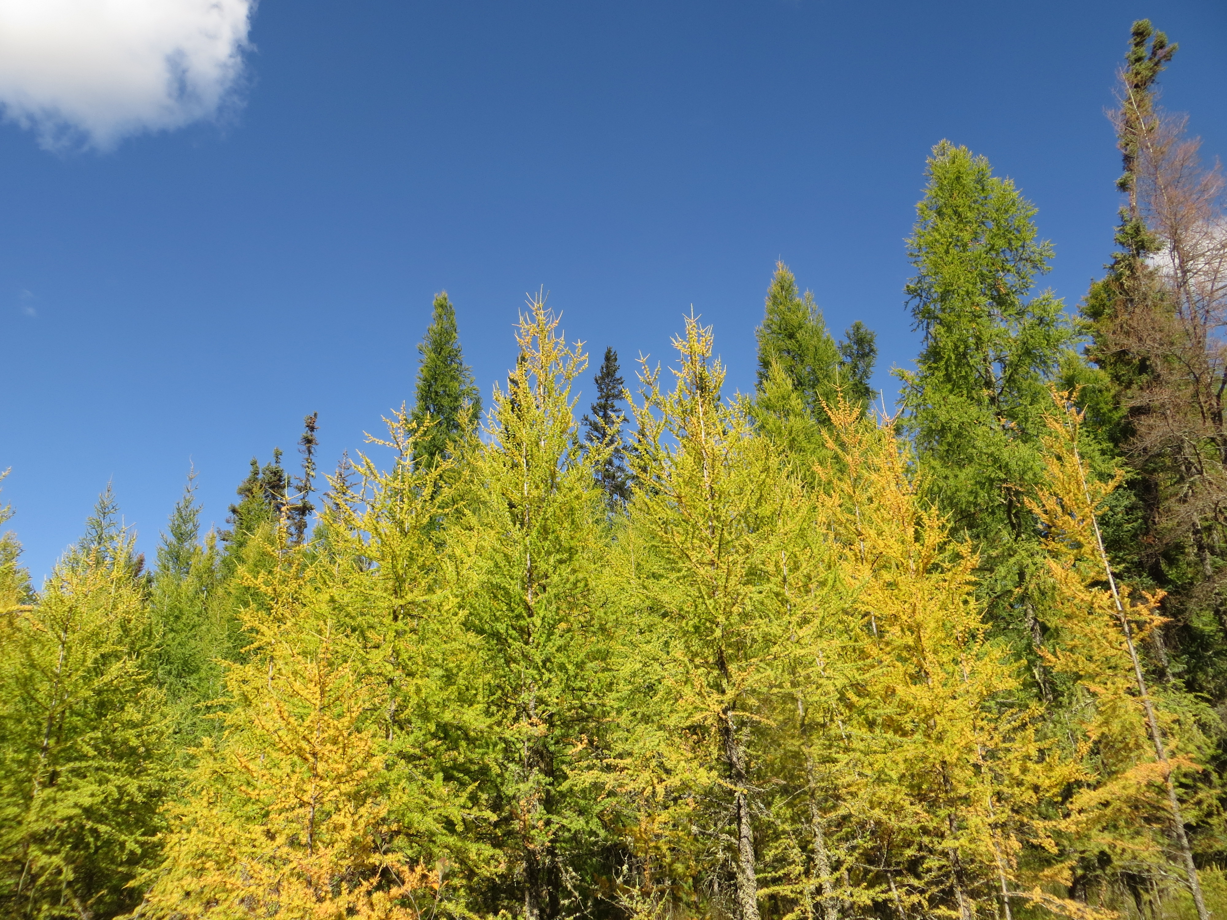
Tamarack (Larix laricina) is a coniferous tree species also known as larch.
Needles are short, soft, and arranged in clusters. Needles are bluish green in colour, but turn yellow and drop in the fall.
Tamarack are found in fens and swamps.
At Evergreen Park they are the dominant species in the tamarack swamps, but they are also found in the treed rich fens and conifer swamps at the Evergreen Centre site.
Tamarack swamps are one of the more abundant wetland types at Evergreen Park. However, many of the tamarack swamps at Evergreen Park have a few interesting features…
Tree cover is:
•Relatively young
•Almost exclusively tamarack
•Very dense
There is well over 40cm of peat in most (but not all) tamarack swamps at Evergreen Park. The photo below is a soil core taken from a tamarack swamp at Evergreen Park. There is over one meter of peat at this location and the soil profile shows that organic soil.
The understory is not very diverse, water levels can be very high, and Equisetum (horsetail) dominates the understory.
Like most swamps, the hummocky (highs and lows) terrain resulting from water-level fluctuations is evident. Water pools that are visible in the spring (left) are usually dried out by the summer (right).
Conifer Swamp
•Characterized by trees that are greater than 10m tall and that comprise greater than 60% of the wetland area.
•Black spruce dominate with dense, tall tree cover.
•May be underlain by shallow, highly decomposed organic soils (typically less than 40cm in depth) with abundant woody debris.
•Conifer swamp is one of two wetland types found at the Evergreen Centre site, but it is only a small area of the Wetland Centre MOU site.
Characteristic Species: Labrador Tea
Labrador tea (Rhododendron groenlandicum) is a short shrub up to 1m tall.
It has evergreen leaves that are oval to linear in shape, smooth edges that roll under, and are dull green above and rusty orange below with dense, woolly hairs.
Flowers are white to pinkish, forming round, umbrella-shaped clusters.
At Evergreen Park, black spruce dominate the conifer swamps and dry to saturated soils with seasonal pools of standing water result in a hummock and hollow microtopography.
Mixedwood Swamp
•Characterized by tree cover more than 25%, including a mix of coniferous and deciduous species (neither dominate).
•Often present in transition areas between peatlands and upland forests.
•Hummocky microtopography may be present and soils may be shallow organic or mineral.
•At Evergreen Park there is only a small amount of mixedwood swamp, found in transition areas between tamarack swamp and uplands.
Typical canopy cover of mixedwood swamps at Evergreen Park.
Hardwood Swamp
•Characterized by deciduous trees greater than 10m and covering greater than 60% of the wetland area.
•White and Alaskan birch dominate, greater than 60% of tree species.
•Saturated to seasonally flooded with pools of water sometimes present.
•This wetland type is typically found in mineral soil drainage areas or riparian floodplains.
- There is only a small area of hardwood swamp at Evergreen Park and it is outside the the Wetland Centre MOU area.
Characteristic Species: White Birch
White birch (Betula papyrifera) is a deciduous tree also known as paper birch.
Bark is dark reddish brown when young, becoming creamy white with age and shedding off in large sheets.
Leaves are 5-10cm, oval, double toothed and with hairy underside.
*White birch photos were not taken at Evergreen Park
Emergent Marsh
•Typically transitional areas between open water and meadow marsh.
•Above surface emergent vegetation greater than 25% of the area and submerged aquatic vegetation is less than 25% or the area.
•Saturated to permanently flooded.
•Common vegetation includes bulrush and cattail.
- At Evergreen Park, the presence of shallow open water appears dependent on annual precipitation and temperature patterns.
The emergent marsh in Evergreen Park is a small area and is heavily impacted by recreational vehicles.
Open Water
While some shallow open water wetlands have been mapped at Evergreen Park, these are primarily anthropogenic features.
That covers all of the wetland types found at Evergreen Park…
Wetland MOU Site
In addition to the diverse wetland types found within the Wetland Centre MOU area, there are a number of other features to consider when planning for access, use, and development.
Upland Ridge
The ridge can be used to access adjacent wetlands to minimize challenges and potential impacts associated with traveling through sensitive sites. There is currently an OHV track that runs along the ridge and connects to north-south OHV tracks that run under the transmission line.
Transmission Line Corridor
A transmission line runs along the eastern edge of the Wetland Centre MOU area.
Off Highway Vehicle (OHV) Use
Evergreen Park and the surrounding area is popular with recreational users. Tracks from trucks, OHVs, and snowmobiles can be found throughout the site. Traffic through wetlands has led to soil compaction and rutting and is evident year-round and from aerial imagery.
OHV tracks through graminoid rich fens and sandy upland sites along the transmission line ROW
Thank you for joining our tour of the wetlands and Wetland Centre site at Evergreen Park.
For information about the Wetland Centre project visit:
For information about Ducks Unlimited Canada’s National Boreal Program visit:
For information about the Evergreen Learning and Innovation Society visit:


