Despite an F4 strength tornado striking a manufacturing plant, casualties were minimal
NWS Lincoln, IL
Overview
Supercell thunderstorms tracked across northern and central Illinois the afternoon and evening of July 13, 2004. A violent tornado tracked for 9.6 miles across Woodford County during the afternoon, with the tornado reaching F4 intensity along a 1-mile stretch between Metamora and Roanoke. It was on the ground for approximately 23 minutes.
Event Overview
The tornado touched down a few hundred yards southeast of the intersection of Illinois Route 89 and county road 1600N. It moved southeast, and strengthened to F2 intensity near the time it reached county road 1300E. It then began a temporary eastward movement for about a half mile, before curving southeast again. It crossed Route 116 just west of the Route 117 junction, and was at F3 strength at this point.
The tornado increased to F4 intensity as it crossed Route 117, demolishing the Parsons Manufacturing Plant at this intersection. Steel beams and metal siding from the plant were found approximately 3/4 mile east in a farm field. From the plant, the tornado continued east, just south of Routes 116/117, affecting 4 farmsteads approximately 1/2 to 1 mile east of the plant. Two of the farmsteads closest to the plant (about 1/2 to 3/4 mile east) had the 2-story houses completely blown away, with only debris remaining in the basements and nearby property. The other two farmsteads had significant damage to the 2-story houses, with outbuildings demolished. The center of the tornado's track was about 100 yards south of the farmsteads on the south side of the highway. From the plant to the farmsteads, the storm was F4 intensity. The average width of the tornado during this time was 400 yards, and was close to 1/4 mile wide at times.
At this point, the tornado began to travel in a more east-southeast direction, and caused significant damage to a barn and farmstead. The tornado lifted around 2:57 pm about 2.5 miles southeast of Roanoke, at county road 1900E.
Parsons Company
Parsons Company operates a plant west of Roanoke. The owner, Bob Parsons, witnessed a tornado near the area in 1974. At that time, the facility he worked at did not have a severe weather safety plan or storm shelters. When he had this plant constructed in 1975, he made sure to include a reinforced concrete block restroom to be used as a storm shelter. As the facility was expanded, additional shelters were added. A formal severe weather safety plan was implemented in 2000.
Photo: Facility before the tornado, found by the NWS storm survey team amongst the wreckage of the front office.
Photo of the Parsons facility before the tornado
Taking Action
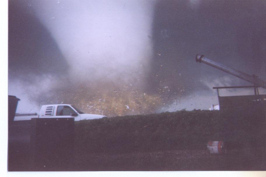
On July 13, the plan was implemented when the Lincoln NWS issued a Severe Thunderstorm Warning at 2:29 pm. Employees trained in severe weather spotting almost immediately noticed a rotating wall cloud, followed by a funnel cloud. Employees were instructed to take shelter, and the process was well underway when a Tornado Warning was issued at 2:34 pm. Verification was made that all 150 people in the building were in shelters by 2:37 pm, and the building was struck by the tornado at 2:41 pm.
Photo: Moment the plant was struck by the tornado. Image by Scott Smith.
Photo of a large tornado striking the Parsons plant
After the Tornado
The tornado completely demolished the Parsons facility. However, of the 150 people in the building, there were only 3 minor injuries.
Photo: Ruins of the Parsons plant, with storm shelters highlighted. Image by Matt Dayhoff of the Peoria Journal-Star.
Tornado Photos
Photo of the tornado while it was located east of Metamora
Photo of the tornado while it was west of Roanoke
View of the tornado looking north from Eureka
View of the tornado looking northeast from Eureka
View of the tornado from Roanoke
View of the tornado looking north from Eureka
View of the tornado looking west from Roanoke
Photo credits:Top (l-r): Jason Malson, Steve Smedley, Brian Bill.
Bottom (l-r): Glade Stutzman, Sharol Minger, Sam Bertschi, Justin Weber.
Radar Images
2:36 pm reflectivity image from the Lincoln Doppler radar
2:36 pm Storm Relative Motion image from the Lincoln Doppler radar
2:41 pm reflectivity image from the Lincoln Doppler radar
2:41 pm Storm Relative Motion image from the Lincoln Doppler radar
Radar images from the Lincoln Doppler radar:Left two -- Reflectivity and Storm Relative Motion images from 2:36 pm
Right two -- Reflectivity and Storm Relative Motion images from 2:41 pm
Damage at Parsons
Wreckage of the Parsons plant, including several crushed cars
Cars stacked atop each other amongst the ruins of the plant
A crushed car in the foreground, and plant wreckage in the background
Parsons plant wreckage
Remains of a tractor-trailer
A concrete wall snapped in half
Steel beam pointing upward from the Parsons wreckage
Photo of one of the tornado shelters after the storm
Destruction of one of the buildings on site
Photo credits:Top left -- Jason Malson; top center and right -- Steve Smedley, Bloomington Pantagraph.
Other photos from NWS.
Other Tornado Damage
Severe damage to a farm building south of Roanoke
Barn damage near Roanoke
A house west of Roanoke is stripped of windows, siding and much of the roof
Remains of a house near Roanoke
Storm damage wrapped around the remains of a large tree
Remains of a farm house near Roanoke
(NWS images)
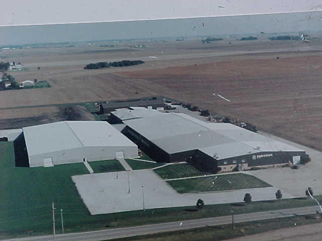
A Rebuilt Parsons
The decision to rebuild the Parsons plant was made within 3 days of the tornado. A new 300,000 square foot facility was designed, with the building shells in place by the end of the year, and the facility reopened the following spring. Two of the original storm shelters remained in place, and an additional 5 reinforced shelters were added to the new facility.
Ironically, the new facility came close to being demolished by another tornado on November 17, 2013, when the Washington EF4 tornado passed within about 2/3 of a mile.