
Colorado Flood Safety & Wildfire Awareness Week, March 6-12
During this week, we will cover a variety of topics about flood and wildfire safety.
Knowing Your NWS Office
The coloring represents the area of responsibility of each NWS CO forecast office for all 64 counties.
Each of the 4 offices has daily forecast and weather warning and alert responsibilities for the their outlined counties.
Four NWS Forecast Offices cover all 64 counties in CO.
Hover over the logos to view the website for each office or simply click the links below to be directed to their local forecast pages.
Sunday - Intro
https://www.weather.gov/safety/lightning
Colorado has more than its fair share of floods, flash floods, and wildfires. Floodprone areas have been identified in over 250 cities and towns and in all 64 counties in Colorado. Over 250 thousand people live in floodplains in Colorado. There are estimated to be 65 thousand homes and 15 thousand commercial, industrial, and business structures in identified floodplains. The value of the property, structures, and contents located in the identified floodplains is estimated to be around 15 billion dollars.
Floods and flash floods have killed over 400 people in Colorado since the turn of the 20th century. The historic weather pattern of September 2013 reminds us all that floods are a major concern across the Centennial state. Floods have caused billions of dollars in damage in Colorado.
Did you know flood fatalities?
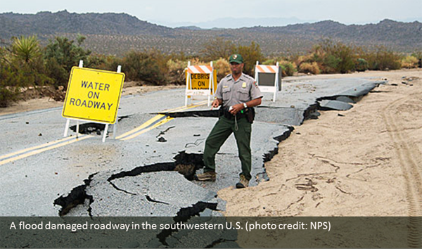
Nearly half of all flash flood fatalities are vehicle related. Do not enter a flooded roadway, instead Turn Around...Don't Drown. In rapidly rising waters, backing up away from water would be safer. One to two feet of water will carry away most vehicles, and you also cannot tell if the road is damaged beneath the water.
Did you know Colorado wildfires?
On average 2500 wildfires occur across Colorado each year. Since 2012, 10 people have been killed when wildfires occurred in the wildland-urban interface (WUI).
Continue to scroll through the StoryMap to learn more about flood and wildfire safety.
Monday - Flood Watches & Warnings
Flood Watch
Yes, there is a difference between a watch and a warning. A watch means the atmospheric ingredients, in order to produce heavy rainfall, will be present on any given day. These ingredients include:
- High atmospheric moisture content
- Slow(er) atmospheric winds allowing storms to slowly drift or remain nearly stationary
- Lifting mechanism, like orographic along hills/mountains, warm/cold fronts
- Storm placement, urban/rural/terrain/burn scar
- Urban Areas - have lots of concrete and asphalt which are impermeable (repel water)
- Rural Areas - have more grass, vegetation, allowing water to drain into the soil
- Terrain/Mountains - are usually steeper and rocky allowing water to quickly flow downhill
- Burn scars - burned soils act a lot like concrete and asphalt, becoming impervious to rain
Flood Warning
A flood warning means flooding has already been reported/experienced or is imminent from heavy rainfall, recent snowmelt, or even a dam failure! In some cases the rain may have already stopped but flooding is still imminent, which can be very deceiving. It takes time for the water to route through smaller streams, creeks, arroyos, so flooding can occur under blue skies after heavy rainfall and even miles downstream where no rain fell at all!
Flood Watch Coverage Areas
Flood watches, like other weather hazard watches, encompass a larger area prior to the heavy rains. The National Weather Service offices typically issue watches anywhere from 4 to 36 hours in advance based on meteorologist confidence, the expected coverage of storms (isolated, scattered, widespread), and the expected areas of impact (see above about storm location).
Flood Warning Coverage Areas
Flood warnings tend to be smaller than the watches as they are issued for certain storms containing heavier rains with targeted impacts and those locations expected to experience those impacts. Depending on the type of warning issued, river flood versus flash flood, the length of the warning will vary from 12-48 hours (river flooding) to 3 hours or less (flash flooding).
Tuesday - River & Areal Flooding
A History of Flooding
Colorado is no stranger to floods. Since the mid-19th century, when record keeping began, Colorado has experienced numerous deadly floods across a large portion of the state. This is especially true from the Colorado Front Range east across the sprawling Colorado plains.
Since 1846, more than 530 fatalities have been documented from floods in Colorado.
The map tour below provides an overview of some of the largest and highest impact long duration floods in Colorado's recorded weather history.

June 1921 Great Pueblo Flood

Memorial Day 1935 El Paso County Flood

June 1965 South Platte Flood

April & May 1999 Eastern Colorado Flood

Historic September 2013 Front Range Floods
June 1921 Great Pueblo Flood
Historic flooding overtook much of downtown Pueblo, CO on June 3rd and 4th of 1921. See storymap for more details and impacts from this catastrophic flood. https://storymaps.arcgis.com/stories/f9bae43a321240c1aef1896a4a7abe5f
Memorial Day 1935 El Paso County Flood
Both Monument and Fountain Creeks overflowed their banks destroying 70 homes and killing at least six people. More information can be found at cspm.org/cos-150-story/1935-memorial-day-flood
June 1965 South Platte Flood
A majority of the flooding across the eastern part of the state was produced by 4 consecutive days of very heavy rainfall from June 14-17. The South Platte River and its sub-basins were hardest hit by this deluge. The flooding would end up costing nearly 4 billion dollars (based on 2018 dollars) in damages. A very comprehensive report on the flooding can be found here: https://pubs.usgs.gov/wsp/1850b/report.pdf
April & May 1999 Eastern Colorado Flood
The most significant river flooding along the Arkansas River since at least 1965 was caused by widespread and persistent rainfall...especially along the eastern slopes of the southeast mountains. The heaviest rainfall occurred from late in the day on the 28th of April and persisted into the afternoon hours of April 30th. Widespread rainfall totals in excess of 8 inches was noted in 40hours with some locations receiving in excess of 13 inches of rain in 48 hours. As stated in April Storm Data, the heavy rain event led to widespread river flooding...especially along the Arkansas River as well as the Fountain Creek watershed. By the morning of May 2nd portions of northern La Junta were under 5 to 6 feet of water, which damaged or destroyed over 250 homes and businesses. Nearly 100 other structures were damaged or destroyed. Many irrigation ditches in southeast Colorado sustained damage to channels and gates. Agricultural lands were swept away, and the channel of the Arkansas River was significantly altered in many locales. Significant flooding occurred between Rocky Ford and La Junta along the Arkansas River. There were numerous roads washed out and bridges destroyed by the flood waters. Water levels began receding in earnest on May 3rd and were generally below flood level by May 5th.
Historic September 2013 Front Range Floods
Historic rains and floods in September caused over 3 billion dollars of damage, and took 9 lives. More information can be found here: https://www.weather.gov/bou/Number1September2013Floods
What does areal flooding even mean?
You've got questions, we've got answers.
Areal means coverage restrained to a particular geographical region. Example: Heavy rainfall produced areal flooding in the county, leaving several dirt roads washed out and a few county roads closed.
River Flooding
River flooding, much like areal flooding, is a longer duration event when compared to flash flooding. River flooding can last for several days depending on what the source of the higher water volume is, spring snow melt, ice jams, and heavy rain across a large area.
Picture to the right shows the extent of the heavy rain into a nearby riverbed that swelled above its banks. The water stays in place (slow-flowing if at all) for a longer duration until the river drains enough for the water to be reclaimed by the riverbed, soaks into the soil, or evaporates.
NWS River Forecasts and Warnings
Four NWS weather forecast offices closely monitor area main stem rivers and their larger tributaries and work with closely with our four NWS river forecast center colleagues to provide accurate and timely river flooding data.
River Forecast Centers (RFC) & WFO Offices
- South Platte River - Missouri Basin RFC (WFO Boulder)
- Arkansas River - Arkansas Red-Basin RFC (WFOs Pueblo & Goodland)
- Rio Grande River - West Gulf RFC (WFO Pueblo)
- Colorado River - Colorado Basin RFC (WFO Grand Junction)
The collaborative process between the weather offices and river offices is rather simple. The RFC hydrologists create a crest and discharge forecast for mainstem river points and the NWS meteorologists relay that information to their end users via river flood statements or warnings. Some river point forecasts send information out daily while others will only send out when in flooding conditions, or expected conditions.
The image to the right is interactive and you can view what services each River Forecast Center offers.
Monitoring River Levels
The National Weather Service created the Advanced Hydrologic Prediction Service monitoring system (see map right). With this system you can easily monitor potential flooding along rivers and large creeks in Colorado. The address for this system is below.
This monitoring system can be accessed on Colorado National Weather Service forecast office web sites by clicking Rivers and Lakes.
Each designated river forecast point in the area is shown on the web page. You can look at current and forecast conditions, flood categories, historic crests, and flood impacts for each site. Probabilities of exceeding certain water levels by week or over the long term are also available.
How Can You Prepare for Floods Now?
In general, there will be some time to prepare for flooding along rivers and large creeks. Emergency management in your area has plans in place to address flooding issues. Know these plans and how you should act when Flood Watches and Flood Warnings are in effect.
For more information on flood safety go to:
Wednesday - Flash Floods
What is a Flash Flood?
A flash flood is defined as a rapid rise in water levels, along rivers, creeks, normally dry washes, arroyos, or even normally dry land areas. Flash floods generally occur within 6 hours of the rainfall or other event that causes them. They frequently happen with little advance notice.
Flash floods frequently result from high rainfall rates, and infrequently result from dam failures, levee failures, or sudden breaks in river ice jams. Flash floods are very destructive due to the force of the moving water and the accompanying debris. This tremendous force can easily damage or destroy roadways, bridges, and buildings.
Flash Floods and Burn Scars
Unfortunately wildfires are a common occurrence in Colorado and where there is fire, there is bound to be burn scar flash flooding and debris flow issues.
As mentioned in the intro section, burned soils act a hydrophobic surface where water is repelled rather than absorbed.
Even moderate rainfall rates can cause significant flooding in the first few years after a forest fire. If you are in or near a burn scar area, you need to plan ahead and be aware of the weather. Rainfall upstream of you can cause a flash flood to come roaring down the mountain to where it is not raining.
The video shows what 1 inch of rain within one-hour can do off a two-year old burn scarred landscape. This was CR 440 in Huerfano County.
Planning Ahead
It is important to know where you are; living, working, driving, recreating.
- If you live, work, drive, or hike along a river, creek, or arroyo, be aware of the weather.
- You should know your flash flood risks, and make your plans to save your life and those around you.
- Be aware of general flash flood plans and procedures that have been developed and implemented by your local emergency management officials.
Remember, NOAA Weather Radio All-Hazards can help greatly once you are out and about on your excursion to provide constant weather information and critical weather warnings
Also, if you have a smart phone, many radar applications can display your location relative to any developing or ongoing thunderstorms.
When A Warning Is Issued
Wireless Emergency Alert (WEA) for a flash flood warning automatically sent to a smartphone.
You need to act quickly!
If you are in a drainage area or in other low spots, walk or climb to higher ground. Know your escape routes and act as quickly as possible. A short walk or climb to higher ground may just save your life.
Many flash flood deaths occur in vehicles. Do not drive through a flooded roadway. The water may be much deeper than you think, because the roadway may be damaged or washed away. One to two feet of water will carry away most vehicles.
If stuck in your vehicle during rapidly rising water, try to escape to higher ground.
August 1904 Eden Flood

1976 Big Thompson Canyon Flash Flood

1997 Fort Collins Flash Flood

July 2021 Glenwood Canyon Flash Flood
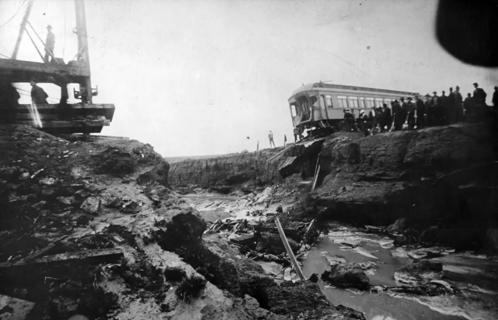
August 1904 Eden Flood
A train bound for St. Louis encountered a significant and catastrophic flash flood just 8 miles of Pueblo, CO at 8 PM on August 7, 1904. As the train started to cross the Dry Creek, the trestle carrying the engine and passenger cars gave way due to the torrents of water rushing beneath it as a big flood wave swept the train from the tracks. The train plunged into the dark water drowning 104 of the 125 passengers onboard. One body was found nearly 22-miles away in Ordway, CO, some others were never found. The engine was submerged deep into mud and sand and the new bridge, completed a mere 24-hours after the accident, was built around the wreckage.
1976 Big Thompson Canyon Flash Flood
After intense rains fell around the mountain town of Estes Park, CO (with totals ranging between 12 and 14 inches), a large wall of water pushed through the Big Thompson canyon, sweeping away houses and cars. Estimated flow along the Big Thompson peaked at over 31,000 cfs. 144 people were killed during the flood making this flood the deadliest flash flood in state history. (Credit Colorado Climate Center)
1997 Fort Collins Flash Flood
On July 28, 1997 the city of Fort Collins received heavy amounts of precipitation. The heaviest amounts of precipitation fell on the west side of town, just east of Horsetooth Reservoir and the foothills. The locally heavy rains, combined with precipitation from the previous day, resulted in rising flood waters along Spring Creek. (Credit Colorado Climate Center)
July 2021 Glenwood Canyon Flash Flood
On the evening of July 29th, extremely heavy rains fell on the nearly year old Grizzle Creek burn scar. The burn scar abuts Glenwood Canyon and the major thoroughfare of I-70 in western Colorado. The heavy rainfall produced a significant debris flow and mudslide trapping over 100 people in their vehicles on I-70. Some were able to follow first responders to a temporary warming shelter, while the majority of people spent the night in their vehicles. Many miles of the heavily traveled interstate were closed for weeks creating a detour over 100-miles in length. The interstate officially reopened in September 2021.
Thursday - Fire Weather & Wildfires
2020 featured several historic fires across a large portion of Colorado. Though wildfires are very common any calendar year, 2020 burned over 800,000 acres and the three largest wildfires in state history occurred within 4 months of one another, Pine Gulch, East Troublesome, and Cameron Peak, burning nearly 750,000 acres combined.
Thousands of residents needed to be evacuated as these wildfires burned close to and unfortunately through communities.
Fire Weather Forecast Continuum
To assist in your preparation for fire, the National Weather Service provides a variety of fire weather forecast products. At least twice a day in Colorado, fire weather planning forecasts are made from each National Weather Service forecast office serving the state.
A Fire Weather Watch may be issued, if in the next 12 to 48 hours, the forecast includes gusty winds of 25 mph or greater, relative humidities of less than 15 percent for at least three hours, dry lightning, or a combination of weather and fuel conditions that may make large wildfires possible.
A Red Flag Warning will be issued if these same critical fire conditions are forecast within the next 12 to 24 hours.
Living in the WUI (Wildland-Urban Interface)
If you live in the WUI there are a number of actions you can take to reduce your personal fire threat, including reducing vegetation near your home and putting a fire resistant roof on your home. This is called 'Defensible Space' and can make a world of difference. We'll talk a bit more about mitigation and protection on Friday.
Whether you live in the WUI or not, preparing for wildfires are crucial to escape injuries. Having or developing a plan now can save time and stress should you be ordered to evacuate due to an approaching wildfires. Wildfires can move at very quick speeds, upwards of 60-70 MPH, at times.
Friday - Wildfire Safety & Mitigation
An important part of weather hazard safety is knowing when you are at risk. Living in the western U.S. wildfires are common occurrence and those living the WUI are especially susceptible to wildfires encroaching on your property and neighborhoods. Below is a step by step process you can use in order to keep you and your loved ones safe during a wildfire.
Recognize Warnings and Alerts
Have several ways to receive alerts. Download the FEMA app and receive real-time alerts from the National Weather Service for up to five locations nationwide. Sign up for community alerts in your area and be aware of the Emergency Alert System (EAS) and Wireless Emergency Alert (WEA), which requires no-sign up.
Make an Emergency Plan
Make sure everyone in your household knows and understands what to do if you need to quickly evacuate.
Strengthen Your Home
Use fire-resistant materials to build, renovate or make repairs. Create defensible space.
Know Your Evacuation Zone
Practice grabbing your go bags, and driving your evacuation route. Always follow instructions from our local authorities as they will provide the latest updates and recommendations to keep you out of harms way.
Gather Supplies
Have enough supplies for your household, including a first aid kit, in your go bag or car trunk.
All of these very useful tips and preparedness plans can be found in much more detail at www.ready.gov/wildfires
Defensible Space
Defensible space is the area around a home or other structure where fuels and vegetation are treated, cleared or reduced to slow the spread of wildfire. Creating wildfire-defensible zones also reduces the chance of a structure fire spreading to neighboring homes or the surrounding forest. Defensible space also provides room for firefighters to do their jobs when fighting a wildfire.
See webpage from the Colorado State Forest Service to the right.
Don't Get Trapped
During periods of extreme fire danger in forests and rangelands...
- Avoid being in areas where you might become trapped by a wildfire.
- Avoid the use of matches, lighters, or anything else which could ignite a fire.
- Make sure that hot parts of motorized equipment, such as mufflers, are not allowed to come in contact with dry grasses or other potentially flammable material.
If you become trapped or cut off by a wildfire, seek shelter in areas with little or no fuel, such as rock slide areas or lakes.
Saturday - Recap Of The Week
Flash Flooding
When a Flash Flood Warning is issued for your area, you need to quickly move to higher ground out of drainages or other low spots. It may be just a short run or climb to that higher ground. Nearly half of all flash flood fatalities occur in vehicles. Do not drive through a flooded roadway. Instead Turn Around, Don't Drown. The water may be much deeper than you think, because it may not be possible to see below the surface of flood waters that the roadway has been washed away. One to two feet of water will carry away most vehicles.
River Flooding
River flooding from snowmelt or persistent rainfall can cause extensive damage to property. There are estimated to be 65 thousand homes and 15 thousand commercial, industrial, and business structures in identified floodplains within Colorado. FEMA has online maps that show if you are in a flood risk area. To access those maps, go to
If you live in a flood prone area, buying flood insurance is the best thing you can do to protect your home, your business, your family and your financial security. To find an insurance agent and obtain other flood insurance information, go to FEMAs national flood insurance program web site at:
As a reminder, there is generally a 30-day waiting period from the time a flood insurance policy is purchased to when it goes into effect.
Wildfires
Normally, the wildfire threat in Colorado increases significantly after the middle of June. Colorado averages about 2500 wildfires each year. About one quarter of all forest fires in Colorado are ignited by lightning. Additionally, many rangeland and grass fires are caused by lightning. Many of these lightning caused wildfires occur in the absence of rain and are the result of what is referred to as "dry" thunderstorms.
Lightning is often accompanied by strong winds from thunderstorms. These winds can quickly turn smoldering organic material into a raging fire. Thunderstorm winds tend to be erratic in direction and speed, posing one of the greatest dangers for firefighters.
How Do Satellites Help?
Besides being able to see the lightning producing storms, satellites, under the right conditions can see wildfire signatures across the landscape. These signatures are known as 'Hot Spots'.
Satellites also measure the temperatures of cloud tops. The colder the measured temperatures, the taller the storm is, and the therefore the more intense the rain may become. This technology, working in tandem with weather radar, allows for quicker alerting of life threatening flash flooding on any given day.
Hot Spots
Wildfire hot spots can be seen from 23,000 miles in space via the GOES-16/17 satellites. Using the different imagery channels on the satellites, offices across the country are able to help detect and direct first responders to new or developing wildfires.
Image on the left shows the darker pixels in southern El Paso County during the nighttime hours of the 117 fire.
Image on the right shows a significant hot spot from the East Troublesome fire jumping over the Continental Divide.
For more information on wildfires and fire safety, please check out the following web addresses:
Thank You!
We sincerely appreciate you taking the time to learn a little more about flood and wildfire safety.


