
Everyone Deserves Safe Streets
Our plan to transform Boston's streets for biking and walking in the next three years
We have a bold plan for transforming Boston's streets to better serve people walking, rolling, and riding bikes.
Over the next three years, we will:
- Expand our bike network so that 50% of residents will be a 3-minute walk from a safe and connected bike route
- Grow our public bike share by 40%, adding more than 100 new stations
- Build speed humps in 30 more community zones, starting with 10 next year
- Add 75 raised crosswalks at parks, libraries, community centers, and schools
- Help 600 women gain confidence in riding bikes
Here's how we're getting there:
- We're quickly closing gaps in Boston's emerging network of low-stress bike routes
- We're launching a citywide design process to bring safer streets to every neighborhood
- We're hiring more people to ensure we have the capacity to do this work well
- We're prioritizing biking and walking across City agencies
Everyone wants to feel safe, no matter where they're going or how they get there.
We are committed to ending serious and fatal injuries that result from traffic crashes on our streets.
In 2019, almost 700 people were seriously injured while walking Boston's streets. Another 365 were seriously injured while biking.
There is no magical solution that will make our streets safer. We must take action in changing policies and design practices. We must work as a community to prioritize safety.
We have the policy and design tools we need.
We can, and must, make changes in every neighborhood to reduce speeding. The likelihood of severe injury or death decreases as drivers' speeds decrease. Our default speed limit is 25 MPH, but on too many streets, people feel comfortable driving much faster.
We have already designed, built, and tested safety tools for Boston's streets. Now, we need to work rapidly to apply these tools in neighborhoods across the City.
Climate change is our reality.
Almost one-third of Boston's greenhouse gas emissions are from transportation. Of that, sixty-five percent are from passenger vehicles. These emissions have created public health and environmental dangers for our residents. And they harm our communities of color disproportionately.
Expanding sustainable transportation is the foundation for reducing emissions, creating shared prosperity, and protecting public health. We must move urgently to improve the accessibility and reliability of our insfrastructure -- including our streets, sidewalks, and transit systems.
Transportation is part of our green public health agenda.
We must use this moment to advance systems-level change to improve public health in Boston. Health inequities are not caused by individual choices or behaviors. They are caused by a system of choices that impact all of us, as a community.
Our social and physical environments shape our health and well-being. Streets that are safer for people mean fewer visits to emergency departments. They can also inspire more people to be active in their daily travels, choosing to walk or bike instead of drive.
And with more people out on the streets, our communities benefit. We feel less stress and more connection to our neighbors. Our mental health improves. Over time, we can see generational benefits. Fewer people will suffer from asthma, from heart disease, and from diabetes.
We already know what works -- because you've told us.
We know that slower speeds save lives.
That clear crosswalks prevent collisions.
That Boston residents deserve a place where they feel safe riding bikes with their kids.
We need a bigger, better bike network.
We know that bicycling is important for Boston today and into the future. We need to make sure our streets are safe for the thousands of people who bike today -- and for the many more who will choose to ride tomorrow.

Research shows that more people will ride bikes if they have access to bike lanes that are separate from vehicles and from pedestrians. And we know that Bostonians want better bike lanes. According to a survey by MassINC Polling Group in 2021 , 50% of Boston respondents probably or definitely would bike more if separated bike lanes were in their neighborhood. And, 77% of Boston respondents supported building separated bike lanes even if some space for driving or parking was removed.
Biking is a natural complement to our public transit system.
It is an option at night, when there is no MBTA service. And, as we're feeling now, it's a useful way to travel during service disruptions on our subway and trolley lines.

There's so much more to do.
During peak times, people on bikes are regularly 10% to 25% of all traffic.

We collect data at 33 locations each June. Bike counts from a typical evening in June 2022 are visualized on this map. You can click the locations to view information about all-day, morning, and evening data. We have more bike data for other years.

In June 2022, more than 13,000 daily trips were taken on Bluebikes -- 7,500 of which started in Boston.
This map visualizes the average number of trips per day per Bluebikes station between April and June 2022.


But our current network is disconnected.
On any given trip, people can experience biking on a path, in a bike lane next to parked cars, or no bike lanes at all.
These gaps in the bike network are not just physical barriers to biking. They are mental barriers, too. A few stressful blocks can prevent someone from taking a trip by bike.
We would not accept this condition for drivers.

As a first step, we plan to connect missing links in today’s bike network.
The City’s bike network will be nearly 20% larger, with an additional 9.4 miles of new bike facilities by the end of 2023.
You'll have 100 miles of comfortable biking in Boston.

Making connections to your cousin's barbecue...
The new bike lanes will increase the number of residents who live within a short walk of the bike network from 28% today to 35% by next winter.


To get to work...
And we will significantly increase access to jobs. Today, 52% of Boston's jobs are within a 3-minute walk of the bike network. By next winter, 72% of jobs will be on or near to the bike network.


To go to your favorite parks...
130 acres of the City's open space will be within a 3-minute walk of a safe, comfortable bike route, including:
- Chestnut Hill Reservoir in Brighton
- Freida Garcia Park in Bay Village
- Paul Gore Beecher Street Community Garden in Jamaica Plain

To pick up groceries...
You can do your regular shopping at any of the 31 grocery stores near the bike network.

To check out Story Time at the library...
You will be able to ride to 11 libraries, including the Central Library.

To meet your child's teachers...
Two dozen schools will be on, or a short walk from, the bike network.

Or to get a check-up.
Seven more community health centers or hospital campuses will be an easy bike ride away.

Our growing bike network will include the types of bike facilities that make the most people feel comfortable: separated bike lanes and traffic-calmed streets.

Separated bike lanes are safe and predictable places for people to ride bikes. You and your family have your own space to ride. You can go at your own pace and ride side-by-side. If you're in a vehicle, you know where to expect people on bikes. You don't have to worry so much. A 13-year study of a dozen U.S. cities found that separated bike lanes make streets safer for everyone -- walking, driving, and biking.


Traffic-calmed local streets are designed for people. They discourage unnecessary through-traffic by drivers, while making useful connections for people walking or bicycling. These streets make it better to:
- travel within your own neighborhood,
- get to train stations or bus stops, and
- connect with the city-wide bike network.


The next ten miles on our bike network:
We're excited to work with you to bring this vision to our streets. Explore each of the street segments in more detail below.
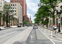
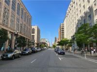
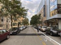
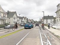
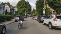
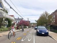
Berkeley Street
Berkeley Street. Click to expand.
Click the arrow switch between our vision and a view of the street today.
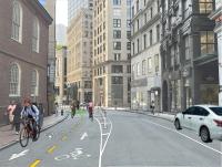
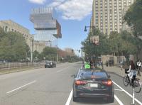
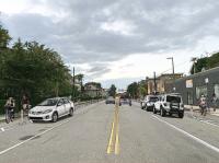
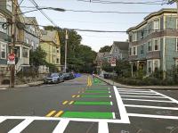
Boylston Street
Boylston Street. Click to expand.
Click the arrow switch between our vision and a view of the street today.
Milk Street
Milk Street. Click to expand.
Click the arrow switch between our vision and a view of the street today.

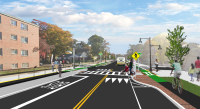
Charles Street South and Tremont Street
Charles Street South and Tremont Street. Click to expand.
Click the arrow switch between our vision for improved crosswalks and an overhead view of the street today.
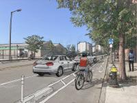
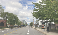
Albany Street
Albany Street. Click to expand.
Click the arrow switch between our vision and a view of the street today.
Hemenway Street
Hemenway Street. Click to expand.
Click the arrow switch between our vision and a view of the street today.
Commonwealth Avenue
Commonwealth Avenue. Click to expand.
Click the arrow switch between our vision and a view of the street today.
Western Avenue
Western Avenue. Click to expand.
Click the arrow switch between our vision and a view of the street today.
North Beacon Street
North Beacon Street. Click to expand.
Click the arrow switch between our vision and a view of the street today.
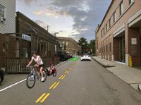
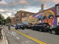
Winship Street
Winship Street. Click to expand.
Click the arrow switch between our vision and a view of the street today.
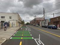
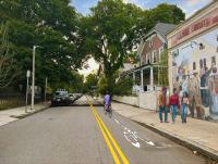
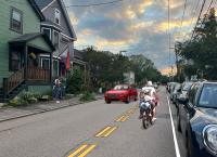
South Street (Brighton)
South Street (Brighton). Click to expand.
Click the arrow switch between our vision and a view of the street today.
South Huntington Avenue
South Huntington Avenue. Click to expand.
Click the arrow switch between our vision and a view of the street today.
Boylston Street (Jamaica Plain)
Boylston Street (Jamaica Plain). Click to expand.
Click the arrow switch between our vision and a view of the street today.
Green Street
Green Street. Click to expand.
Click the arrow switch between our vision and a view of the street today.
Seaverns Avenue and Gordon Street
Seaverns Avenue and Gordon Street. Click to expand.
Click the arrow switch between our vision and a view of the street today.
Eliot Street
Eliot Street. Click to expand.
Click the arrow switch between our vision and a view of the street today.
McBride Street
McBride Street. Click to expand.
Click the arrow switch between our vision and a view of the street today.
Poplar Street
Poplar Street. Click to expand.
Click the arrow switch between our vision and a view of the street today.
Cummins Highway
Cummins Highway . Click to expand.
We will completely rebuild Cummins Highway, from Fairway Street to Wood Avenue/Harvard Street. We will repave the road, rebuild the sidewalks, add new street lights, add more trees, and replace or update utilities as necessary.