
Priest River Experimental Forest
Explore the history of Priest River's long-term research projects, facilities, & other points of interest.
Click on points of interest to highlight their location on the map - Scroll through photos and timeseries - Click the "i" information icon to the left of each photo for details

Priest River Headquarters

Headquarters Overlook Timeseries

Headquarters Weather Station

Weather Tower

Wellner Cliffs RNA

Canyon Creek RNA

Gisborne Lookout Tower

Experimental Point

Benton Nursery

Benton Nursery Historical Timeseries

Ponderosa Pine Seed Source Study

Historical Weather Stations

Benton Meadow Snowcourse

Benton Creek Gaging Dam

Benton Watershed Study

Assisted Migration Adaptation Trial (AMAT) Study

Great North Idaho Bedding Experiment
Western White Pine Vigor Quality Plots

Ida Creek Western White Pine Plantation

Canyon Creek Western White Pine Plantation

Free Selection Silviculture Research

Ponderosa Pine Prescribed Fire and Shelterwood Study

Clearcut Transect

Study Plot 106 (Tree Thinning Methods)

Study Plot 122 (Growth, Yield, & Mortality Research)

Study Plot 151 (Undisturbed Stand Measurements)

Long-Term Soil Productivity Plots

Weidman Arboretum
Priest River Headquarters
The headquarters compound includes several buildings that are used for research and education purposes. Priest River Experimental Forest headquarters area includes: Photo 1 - The Lodge (constructed in 1934 and listed on the National Register of Historic Places); Photo 2 - The Conference Building (constructed in 1998); Photo 3 - The amphitheater (constructed in 1976); Photos 4 & 5 - The Office-Laboratory (constructed in 1936 and listed on the National Register of Historic Places); The Bunkhouse (constructed in 1933 and listed on the National Register of Historic Places); Cabin 2 (constructed in 1934 and listed on the National Register of Historic Places); And Cabin 3 (constructed in 1936 and listed on the National Register of Historic Places). See the "i" information icon to the left of each photo for more information.
Headquarters Overlook Timeseries
This series of five photos shows the headquarters area at Priest River over a 60-year period as seen from Crows Nest Hill (located just to the southeast of the headquarters). The photos in this timeseries include: Photo 1 - taken in 1915, shortly after the Experimental Forest was established; Photo 2 - taken in 1924; Photo 3 - taken in 1941; Photo 4 - taken in 1953; and Photo 5 - taken in 1976. See the "i" information icon to the left of each photo for more information.
Headquarters Weather Station
The primary or "control" weather station at Priest River was moved in 1916 to the present location in the headquarters area. Continuous climate data has been recorded since then. The complete record of daily weather observations made at Priest River can be accessed from several websites, including the National Climate Data Center ( find data here ). In 2003, Priest River Experimental Forest became a member of the National Trends Network of the National Atmospheric Deposition Program ( find data here ; site code ID02). See the "i" information icon to the left of each photo for more information.
Weather Tower
In the late 1920s forest fire researcher H.T. Gisborne began to maintain weather instruments at the top of a live 150-foot tall, 3-feet in diameter western larch tree located next to the headquarters area. The western larch "weather tree" was gradually replaced beginning in 1934 with the construction of the 150-foot tall "weather tower" just to the west of the headquarters area, that was erected in 1934 with the aid of Civilian Conservation Corps labor. The tower was used for studying variations in climate within the forest from the ground up through the canopy. Wind velocity, air temperature, and relative humidity were measured continuously with automatically recording instruments at five levels on this tower during the summers from 1938 through 1941. Gisborne established a series of other weather trees located at different areas with the Experimental Forest where he monitored weather to study the possibilities of predicting fire danger. See the "i" information icon to the left of each photo for more information.
Wellner Cliffs RNA
The Wellner Cliffs Research Natural Area (RNA) was established by the Forest Service within Priest River Experimental Forest in 2004 (Photo 1). This RNA encompasses 307 acres (124 ha) and elevations range from 2,460 feet (750 m) where Canyon Creek (Photo 2) exits the RNA to 3,800 feet (1,160 m) at the northeast boundary. Wellner Cliffs RNA contributes to a national network of ecological areas dedicated to research, monitoring, education, and maintenance of biological diversity. The RNA serves as a reference area for the study of ecological processes, not only as part of the overall RNA system, but also as a reference area for studies on adjacent parts of the Experimental Forest. Within the RNA, habitats quickly change from mixed conifers on deep soils, to dry open ponderosa pine forests, to shrub and grasslands on shallow soils, to exposed rocky cliffs with high lichen diversity (Photo 3). The Wellner Cliffs RNA is mostly a southern exposure, but the riparian area also includes north-facing slopes on the south side of Canyon Creek. Topography in the Wellner Cliffs RNA is gentle along Canyon Creek, extremely steep in the cliffs (with numerous vertical drop-offs), with moderate slopes above the cliffs. See the "i" information icon to the left of each photo for more information.
Canyon Creek RNA
The Canyon Creek Research Natural Area (RNA) was established by the Forest Service within Priest River Experimental Forest in 1937 as an example of virgin, old-growth western white pine type forest (Photos 1& 2) to preserve for research, educational, and demonstrational purposes. It is 977 acres in size (395 ha) and ranges in elevation from 4,150 feet at the point where Canyon Creek (Photo 3) flows out of the area to 5,900 feet at the extreme southwest corner. The grassland on south side "bald" in the Canyon Creek RNA is an area of prairie-like vegetation (Photos 4 & 5) surrounded by belts of shrubs and scattered trees, and then by dense forest. See the "i" information icon to the left of each photo for more information.
Gisborne Lookout Tower
The Looking Glass (later renamed Gisborne) fire lookout was constructed in 1933 (Photo 1) with government funding from the Civilian Conservation Corp on a highpoint near the southern border of the Experimental Forest. For several years the lookout was manned daily during the fire season (generally from May or June to late October or early November). After the death of pioneer forest fire researcher H.T. Gisborne in 1949, Looking Glass Mountain and Looking Glass Lookout were officially renamed Gisborne Mountain and Gisborne Lookout in 1951(Photo 2). Gisborne Lookout was completely reconstructed in 1958, and this structure has been maintained to the present day. The Lookout underwent major renovation in 1991, and a new roof that was added in 2009 (Photo 3). See the "i" information icon to the left of each photo for more information.
Experimental Point
The Experimental Point Lookout was constructed in 1917 on the very southeasterly tip of the Experimental Forest in an area that was already commonly known as "Experimental Point" (Photo 5). This lookout was used by Forest Service researchers, fire-lookout personnel, and also occasionally visited by the general public, until October 9, 1932 (Photo 4). The Experimental Lookout was probably torn down around 1933, following the construction of the neighboring Looking Glass (later renamed Gisborne) Lookout Tower was complete. Only a bit of debris and a Geological Survey marker are now at the location where the Experimental Point Lookout stood at PREF for sixteen years (Photos 1 - 3). See the "i" information icon to the left of each photo for more information.
Benton Nursery
Several long-term studies were established at the Benton Nursery. These include: (1) Photo 1 - A western white pine plantation was established in the Benton nursery in 2010 with seedlings supplied by the Inland Empire Tree Improvement Cooperative (IETIC). The trees were propagated by the IETIC from the original seed collections made in the 1950s and 1960s from blister rust resistant trees under the supervision of Richard T. Bingham. More IETIC "Bingham graft" western white pine seedlings were planted in the PREF nursery in 2012 and 2015; (2) Photos 2 & 3 - The "Inter-varietal Hybrid Douglas-fir" plantation at the Benton Nursery was established by researchers in 1995. These hybrids were developed at the Moscow Forestry Sciences Lab to incorporate the growth potential of the coastal variety (Pseudotsuga menziesii var. menziesii) with the frost hardiness of the interior variety (Pseudotsuga menziesii var. glauca); (3) Photos 4 & 5 - The "Pollen Cloud" study examined potential resistance of white pine to white pine blister rust by the removal of infected trees. Western white pine seedlings grown at the Coeur d'Alene Nursery were replanted at the Benton Nursery in 2009. Later, western white pine seedlings grown from seed that survived a white pine blister rust artificial inoculation at the Coeur d'Alene Nursery were replanted at the Benton Nursery in 2011 to monitor their progress. See the "i" information icon to the left of each photo for more information.
Benton Nursery Historical Timeseries
An experimental nursery test site was cleared and plowed on Benton Flat in September 1911 at the newly established Priest River Experiment Station (Photos 1& 2). Several experiments for planting, nursery, and seed research projects were started on this area in September to November and the first meteorological station was set up right by the transplant beds. The use of the Benton Nursery greatly declined in the 1920s, with the transfer of almost all regional planting, nursery, and seed research projects to the Savanac Nursery. In the early 1970s the advent of genetics research projects on a variety of tree species took advantage of the Benton Nursery as a plantation test site. The extensive use of the Benton Nursery for genetics, silvicultural and pathology projects has continued from the 1970s to the present day. Timeseries photos of the nursery include: Photo 3- taken in 1935; Photo 4 - taken in 1979; and Photo 5 - taken in 2005. See the "i" information icon to the left of each photo for more information.
Ponderosa Pine Seed Source Study
In 1911 to 1917 a ponderosa pine source-of-seed study plantation was established in Benton Flat Nursery. The seed originated from locations on eight national forests in Idaho, Oregon, California, Arizona, Colorado, South Dakota, and Montana. The objective was to see which of the varieties would produce the best timber in the shortest time in the local climate. The trees on this plot were intensively studied in 1920s to the 1980s, with results regularly reported in several publications, and the plot gained a world-wide reputation as a pioneering study-site in the field of tree population genetics. A timeseries of the ponderosa pine development in Plot 162 of the study is included above: Photo 2 - taken in 1915; Photo 3 - taken in 1922; Photo 4 - taken in 1932; and Photo 5 - taken in 1976. In 2016 the plantation was cleared of debris, other growth of trees and shrubs, and dead fire-hazard plantation trees (Photo 1). See the "i" information icon to the left of each photo for more information.
Historical Weather Stations
The climate record of Priest River Experimental Forest began in 1911 with the Benton Flat Nursery weather station (Photos 1 & 2), and included observations of temperature, precipitation, humidity, and wind. Two additional climate monitoring stations were set up in 1911 on different forest types at lower northeast and southwest slopes of the Benton Creek drainage (Photo 3) to determine the general climatic characteristics of the region and the ecological differences. The primary or "control" weather station at Priest River was moved in 1916 to the present location in the headquarters area (Photos 4 & 5). See the "i" information icon to the left of each photo for more information.
Benton Meadow Snowcourse
The Benton Meadow and Benton Spring snow courses were first established within Priest River Experimental Forest in 1937 (Photos 1 & 2). The current Benton Meadow snow course site is located just to the southwest of the headquarters area at 2,375 ft. elevation. Benton Spring snow course is located in the upper Benton Creek drainage at 4,777 ft. elevation. Measurements of snow depth, core length, and water content are made each year at the Benton Meadow and Benton Spring snow courses beginning on or about January 1 (± 2 days) and continuing monthly to the 1st of May or melt out, whichever comes first (Photos 3 & 4). This information is forwarded to the Natural Resource Conservation Service ( find data here ) for use in their water supply forecasts. See the "i" information icon to the left of each photo for more information.
Benton Creek Gaging Dam
The earliest reservoir and dam site on Benton Creek at Priest River was constructed in the fall of 1911 to provide a water supply for the newly established Priest River Experimental Station (Photo 5). This location was at 3,200 feet up the creek from the headquarters area, at the site of the present dam. The Benton Creek streamflow dam and gaging station became operational in 1939 and has been recording data almost continuously to the present day (Photo 1). The Dam pond requires periodic cleaning (Photos 2 & 3) See the "i" information icon to the left of each photo for more information.
Benton Watershed Study
In 2003 a large study was initiated at Priest River (referred to as the "Benton Watershed Study") to determine the effects of prescribed fire and mechanical alternatives for forest fuel reduction on runoff and soil erosion. Ten sub-drainages on southerly aspects in the Benton Creek watershed (with an average size of 3.8 hectares) were selected for the application of fuel reduction treatments. The purpose of this study is to measure the watershed impacts of current forest fuel management practices, simulated wildfire, and to present the runoff and erosion rates observed on these watersheds prior to and following any treatment in order to evaluate natural variability in small watershed studies. The treatments applied for the Benton watershed study consisted of commercial thinning followed by prescribed fire, commercial thinning followed by mechanical slash treatment (mastication), simulated wildfire, simulated wildfire followed by salvage logging, and control sites with no treatment. Several study plots were established at each site to collect pretreatment data (including estimates of percentage litter, fine and coarse woody debris, grass, forbs, and shrubs) and to monitor and record the post-treatment effects. Catchments, known as "h-flumes" (used for the anticipation of lower flows in the control, thinned, and masticated sites) and "V-notch weirs" (used for the anticipation of higher flows in sites with simulated wildfire), were installed at the bottom of study-units in the Benton watershed study (Photo 4). These installations enabled researchers to monitor water flow and sediment migration. Two paired drainages were burned in October 2006 by local Forest Service fire crews to simulate wildfire in the Benton watershed study (Photos 1-3). Each watershed was ignited with propane torches around the perimeter, from the top to the bottom. A fire break was manually dug around each watershed and a fire hose laid around the perimeter prior to burning. The long-term effect of the forest fuel reduction treatment applications on forest structures and on disease and insect infestation are being observed on the Benton watershed study-units (Photo 5). See the "i" information icon to the left of each photo for more information.
Assisted Migration Adaptation Trial (AMAT) Study
A crew from the British Columbia Ministry of Forests planted seedlings in 2012 at a site in the Benton Creek drainage for the Assisted Migration Adaptation Trial (AMAT; Photo 1). The two-hectare AMAT site is the Benton Creek Title IV simulated wildfire unit 8. This project is ongoing will track the progress of the seedlings as part of a long-term study of climate warming and its effect on the range of native and non-native conifer species (Photo 2). The crew also installed a weather station to monitor the conditions at the site. See the "i" information icon to the left of each photo for more information.
Great North Idaho Bedding Experiment
A study to evaluate the effects of site-preparation treatments on the long-term growth and productivity of interior Douglas-Fir, western larch, and western white pine was started in 1982 (named the "Great North Idaho Bedding Experiment"; Photo 1). Several clear-cut areas throughout the Experimental Forest were selected for the site-preparation experiments. The GNIBE study treatments were replicated across sites and included: (1) no site preparation, (2) scalping organic matter and mineral topsoil, (3) mounded bedding with competition not removed, and (4) mounded bedding plus three years of competition control with herbicide (Photos 2 & 3). Each treatment was planted with 240 containerized one-year old Douglas-fir or western white pine seedlings (grown from locally collected seed) in April 1983. The soils at GNIBE study site were sampled before treatment and during the first three years after planting to be analyzed for chemical and physical characteristics. A small number of seedlings from each tree species were excavated at approximately 6-week intervals during the first three years after planting to measure height, biomass, root development, and ectomycorrhizal development (Photo 4). The GNIBE study sites have been regularly monitored and maintained over the years including the removal/thinning of natural tree regeneration (Photo 5). In 2017, at 34 years of age, the growth and yield of trees at the GNIBE study plantations were compared among the treatments, and models of growth were developed for each species and treatment combination. See the "i" information icon to the left of each photo for more information.
Western White Pine Vigor Quality Plots
In 1955 to 1959, some of the earliest plantings of white pine blister rust resistant western white pine developed by a group of researchers led by R.T. Bingham were made in what is known today as the "vigor quality plots" (VQ). These plantations were established to determine the tree growth and form characteristics, in addition to the levels of blister rust resistance produced. By 1975 the VQ plots were producing seed with a high degree of blister rust resistance. The results of the VQ plots have shown that many of the western white pines exhibiting rust resistant characteristics have excellent form and growth, validating the techniques being used by R.T. Bingham to develop the new genetic strains. For decades, the VQ plots have produced seed with a high degree of blister rust resistance that have been used to produce plantations located throughout the Northwest, thus protecting the forests from the previous devastation caused by this disease. The VQ timeseries photos show development of the resistance western white pine trees over the past ~50 years, including: Photo 1 - VQ plots in 1968; Photo 2 - VQ plots in 1975; Photo 3 - VQ plots in 2006; Photo 4 - VQ plots in 2017; Photo 5 - VQ plots in 2018. See the "i" information icon to the left of each photo for more information.
Ida Creek Western White Pine Plantation
The "Ida Creek" provenance test involved one of three areas established within the Experimental Forest in 1971 to assess the variation in growth and survival among seed sources of western white pine. Seeds were collected from different elevations in the interior northwestern USA. This plantation, located in the small Ida Creek drainage, was designated as the "low elevation" study-site. The "Ida Creek" plantation (0.8 ha in size and at 970 meters elevation) and the other two elevational test sites established in 1971 were planted with trees that originated from seeds in wind-pollinated cones collected from 48 natural western white pine provenances on three national forests in northern Idaho (Clearwater, Kaniksu, and St. Joe) and from eight additional provenances in western Washington and one provenance in the Blue Mountains of northeastern Oregon. Measurements on the survival, height growth, and diameter at breast height growth were collected over multiple years at the "Ida Creek" plantation until 1987 (Photo 1). In 1987, 16 years after outplanting, the root collar and major lateral roots of each tree within the Ida Creek provenance plantation (including 2,076 living or recently dead trees) were inspected for Armillaria root disease. Epiphytic rhizomorphs, mycelial fans, and rotten wood samples were collected and cultured for Armillaria. These samples resulted in 1,221 Armillaria isolate collections. Extensive tests were made on the Armillaria collections to determine the species, the individuals, their association with disease and habitat type, and their relationship to growth and survival of the western white pine trees on the site. The Ida Creek plantation continues to provide a site for provenance research (Photos 2 & 3). See the "i" information icon to the left of each photo for more information.
Canyon Creek Western White Pine Plantation
In April of 1971, western white pine seedling that survived artificial white pine blister rust inoculations (numbering 12,414) were transported from the Moscow Forestry Sciences Lab and outplanted (with the assistance of a Falls Ranger District crew) on a 17-acre area of the lower Canyon Creek drainage (3,100 feet elevation). This plantation, known as the "Western White Pine Canyon Creek Tree Improvement Area" provides a large reservoir of known genetic material for future experiments on traits of white pine blister rust resistance and information on the relationships between seedling symptom history and long-term resistance. Activities at the Western White Pine Canyon Creek Tree Improvement Area include a "Vertical Resistance Study" initiated in 1993 that involves the use of seed collections resulting from artificial pollination/fertilization crosses among parents from three white pine blister rust resistance traits. A "Realized Gain Trial" was initiated in 2003 to study survival among the resistance mechanisms and correlation between rust resistance and growth. The Western White Pine Canyon Creek Tree Improvement Area is now widely known as a white pine blister rust-resistant western white pine tree breeding plantation/orchard (Photos 1 & 2). With the assistance of personnel from National Forests, the Priest Lake Ranger District, and other agencies, cones, pollen, and/or scion materials have been collected from trees at the Western White Pine Canyon Creek Tree Improvement Area almost annually since 1988. Eighty bushels of cones were recovered by Priest Lake Ranger District personnel from the plantation in 1993 (Photos 3 & 4). These materials have been used by universities, government agencies, and other cooperators in the United States and Canada for a variety of purposes, including reforestation, rust-resistance breeding programs, new seed orchards, and genetics research. See the "i" information icon to the left of each photo for more information.
Free Selection Silviculture Research
The free selection silviculture system is a multi-aged management strategy where the primary objective is to strategically create a variety of compositional and structural patterns. Adjusting the frequency, size, and juxtaposition of patches and stands contributes to a disturbance resilient landscape. The free selection silviculture system has been practiced and developed at Priest River Experimental Forest since 1976. Forest structural patterns and forest gaps were created to study through various methods, including burning, mastication, and grappling (Photos 1-3). In the most recent iteration, overstory removal treatments were conducted in 2007. A wide variety of conditions were created as part of this project, with canopy openness ranging from 25-45% in some locations, to over 92% in others. This range of conditions allows us to study stand development across a variety of conditions. Researchers are continuing to remeasure tree growth, regeneration, and understory vegetation community response to treatments. See the "i" information icon to the left of each photo for more information.
Ponderosa Pine Prescribed Fire and Shelterwood Study
In 1986, a study was established at three replicated study locations near the top of Center Ridge at Priest River Experimental Forest. A total of 15 study-unit plots (5 prescribed fire regime treatments x 3 replicates), each ranging from 5 to 10 acres were established. The goal of the study was to test shelterwood cutting applied in conjunction with prescribed fires in both moist and dry duff to encourage ponderosa pine regeneration. Researchers measured the effects of burning on fuel consumption, overstory damage and subsequent growth, and undergrowth competition. Pre-and post-burn vegetation and forest-floor fuel inventories were made on permanently marked plots in each study-unit. Permanent photo-points were established at each study-plot, and photos were taken to record pre and post treatment conditions: Photo 1 - pre- treatment (1988); Photo 2 - post-treatment (1989); Photo 3 - 5-years post-treatment (1993); Photos 4 & 5 - 30-years post-treatment (2009). See the "i" information icon to the left of each photo for more information.
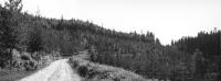
Clearcut Transect
The area known as the "Clearcut Transect" is a 330-foot wide by 0.83 miles long strip of forest in the Benton Creek drainage that was cleared of all timber in 1941-1942 originally for the purpose of measuring differences in fire danger from the ridgetop to a creek bottom. Although the original study planned was not carried out, several other studies have been conducted there. In the 1940's research was conducted to determine the effects of cover, aspect, slope position, and elevation on snow accumulation and melt (Photo 1). In 1949, twelve temporary snow course installations were set-up on the upper, middle, and lower slope positions. Researchers conducted a tree reproduction survey on the Clearcut Transect in 1962-1965, and subsequently a tree thinning study was installed in 1967 at seventeen plots located on the north facing slope (Photo 2). Climatological and snow course stations were reestablished by researchers in 1967 on and adjacent to the Clearcut Transect to determine if vegetation had recovered enough over the 32-year period to have affected snow accumulation and melt (Photos 3 & 4). Data was collected by researchers at the new climatological and snow course stations on and next to the Clearcut Transect and at several other locations in the Benton Creek drainage over the period 1967 to 1974. The study-plots established at the Clearcut Transect in 1967 were remeasured by University of Idaho researchers in 2018 and the data was analyzed and published. See the "i" information icon to the left of each photo for more information.
Study Plot 106 (Tree Thinning Methods)
Permanent Plot 106 is one of several permanent study-plots established at Priest River and throughout the northern Rocky Mountain region. The permanent study plots are maintained by the Forest Service to collect reliable information in order to make the best decisions on how to manage these dynamic, complex forest ecosystems. Plot 106 is one of four half-acre sized plots established in 1919-1920 in a 70-year-old stand on the north side of Benton Creek to study methods of tree thinning. Timeseries photos of Plot 106 shown above include: Photo 1 - taken in 1920, just after establishment; Photo 2 - taken in 1929; Photo 3 - taken in 1934; and Photo 4 -taken in 1939. See the "i" information icon to the left of each photo for more information.
Study Plot 122 (Growth, Yield, & Mortality Research)
Permanent Plot 122 at Priest River Experimental Forest (0.25-acres in size) was first measured in 1912 to study the growth, yield, and mortality of trees in a 45-year-old undisturbed stand. It is located on the north side of Benton Creek (about one-eighth mile up from the headquarters area) and has been remeasured at five to 15-year cycles since 1916. Photos 1-4 show the photo points taken from each corner of the plot. See the "i" information icon to the left of each photo for more information.
Study Plot 151 (Undisturbed Stand Measurements)
Permanent Plot 151 at Priest River Experimental Forest (0.8-acres in size) was first measured in 1928 to study the growth, yield, and mortality of trees in a 300-year-old undisturbed stand. It is located in the upper Benton Creek drainage on the south side (at 4200 ft. elevation) and has been remeasured at five to 15-year cycles since 1928. Timeseries photos of Plot 151 shown above include: Photo 1 - taken in 1932; Photo 2 - taken in 1943; and Photo 3 - taken in 1953. See the "i" information icon to the left of each photo for more information.
Long-Term Soil Productivity Plots
In 1991 a study to evaluate the effects of timber harvesting and site preparation on changes in the bulk density of forest soils in northern Idaho was initiated. The study is located just up from the Priest River on the western edge of the Experimental Forest, divided into nine 0.8 ha plots. This site is a part of a world-wide cooperative Long-Term Soil Productivity (LTSP) network designed to provide a controlled and extensively replicated experiment to isolate and study the soil disturbance effects of compaction and organic matter removal. Treatments involving three levels of residual organic matter and three levels of site preparation/soil compaction during tree harvest were tested at the Priest River LTSP plots. Data at these plots were collected and analyzed regularly over the following 30-year period together with data collected at more than 100 LTSP sites across North America. See the "i" information icon to the left of each photo for more information.
Weidman Arboretum
An area of about 100 acres was set aside within the Experimental Forest in 1929 as an arboretum to be planted with native and exotic tree species. The arboretum was named after R. H. Weidman, third Director of the Northern Rocky Mountain Forest and Range Experiment Station, who planned the arboretum and personally supervised most of the plantings made in 1931 to 1935. Of the 59 tree species that were planted at the Weidman Arboretum, twenty-nine apparently had either no growth or poor growth or had died by 1936. This was typical of many other similar attempts to establish exotic plantations around the United States. Since shortly before World War II the arboretum has received little care because of reduced operational facilities on the Experimental Forest. Although there has been no intensive survey made in the last thirty years of what species have survived at the Weidman Arboretum, in 2023 researchers found many large European larch (Photos 1 & 2) and Norway spruce (Photos 3 & 4) trees still thriving. See the "i" information icon to the left of each photo for more information.
This map is intended for historical and informational purposes. Pin locations are not exact coordinates. Please contact Scientist-in-Charge Jason Reinhardt or see Priest River Experimental Forest website for updates about research and data.
Photos and historical information compiled by James Donley
Story Map development by Hannah Farrell