A Virtual Tour Along the Dynamic Muddy Creek
A virtual tour highlighting the wildlife, habitats, and dynamic processes that have shaped the backbone of Erie NWR's Seneca Division.
Muddy Creek & the French Creek Watershed
Figure 1. The streams and sub-basins of the French Creek Watershed. The Muddy Creek sub-basin is shown in orange. Credit: USFWS
Muddy Creek forms the backbone of Erie National Wildlife Refuge's Seneca Division, flowing along a 10.5 mile stretch within the refuge. Roughly half of the length of Muddy Creek is located within the Seneca Division. It is also one of 10 major sub-basins (or sub-watersheds) of the French Creek watershed .
The entirety of the refuge lies within the French Creek watershed, which is considered an ecologically significant watershed nationally, and in Pennsylvania, with globally rare freshwater mussels and fish.
French Creek's headwaters begin in southwestern NY, near the town of Sherman, and flows approximately 117 miles, through Erie, Crawford, Mercer, and Venango Counties before converging with the Allegheny River in Franklin, PA (Figure 1).
French Creek is among the most biologically diverse streams in Pennsylvania and the eastern United States, providing habitat to more than 89 species of fish, 28 species of freshwater mussels, and the official amphibian of Pennsylvania, the eastern hellbender (Cryptobranchus alleghaniensis alleganiensis) (WPC 2009).
A Short History of the Land and Its Original People
The area where the refuge lies today was originally populated by the indigenous Erie people, who lived in fortified villages, stored maize among other foods, and tended to the land, using techniques like burning to improve agriculture. It is believed that these native people had relatively little influence on ecological processes or communities in the valley creeks and wetlands of the region.
The map above models the potential vegetation communities that would have historically occurred within the Seneca Division prior to European settlement, and was produced using relationships of vegetation communities to soils, topography, hydrology, and geomorphology. Vegetation communities were primarily comprised of floodplain shrub wetland (cyan), swamp forest (purple), transition forest (orange), and upland hardwood forest (green). Credit: Heitmeyer and Aloia
Following European settlement, the fur trade with European settlers brought the Iroquois Nation to the region, culminating in a war involving the Iroquois (Seneca people) who defeated the Erie in 1655 and caused the Erie to abandon the French Creek Valley. Additional Native American tribes settled in the area as European settlement pushed westward, though these settlements remained sparse due to European disease and continued conflicts.
In the late 1700s and early 1800s, European settlements increased throughout the region, with large areas of forests cleared for timber harvest, subsistence farming, and agriculture. Impacts from timber removal included increased rates of soil erosion from cleared hillsides, which caused heavy sedimentation in creek valleys. Over time farming shifted to raising cattle, sheep, and horses as soils were well suited to producing grasses that provided good forage for stock. By the late-1800s the farming population began a steady and slow decline as mechanical farming tools reduced labor and industrial growth increased in cities. Farming continued to decline through the 1900s, with many farmlands being abandoned.
The Creation of the Seneca Division
The lands surrounding Muddy Creek, which make up the Seneca Division of Erie National Wildlife Refuge, were approved for acquisition into the National Wildlife Refuge System by the Migratory Bird Commission in 1967, with the first tracts, totaling 3,027 acres, being purchased in 1973. Today, the Seneca Division consists of 3,753 acres, much of which is wetland or forested habitat, but also contains abandoned crop, hay, pasture, and orchard lands. The conservation of these lands provides refuge for hundreds of species, while also forming a forested buffer that protects Muddy Creek and its tributary streams, wetlands, and other aquatic resources from development, habitat fragmentation, and habitat degradation.
Muddy Creek gets its namesake from its muddy, brown-colored waters. Credit: USFWS
The Waters of the Muddy Creek Sub-Basin
It is believed that Muddy Creek received its namesake due to its "muddy" brown waters. This color is created as the creek meanders along highly erodible exposed soil streambanks, which create the turbid characteristics of the stream. This trait, however, is increasingly influenced by land use activities upstream, which have influenced Muddy Creek and its water quality.
Though recent assessments have not identified any acute water quality issues within Muddy Creek, the turbidity of the creek has increased over time, as documented by water quality monitoring of Muddy Creek and its tributaries (Patnode 2012) . This is mainly caused by farming and grazing practices, which increase sediment loads and agricultural fertilizers (or excess nutrients) entering the creek and its tributary streams. One upstream tributary of Muddy Creek has also been listed as impaired by the EPA due to siltation from these practices.
Other inputs such as salt and brine applied to country roads may negatively impact surface water and infiltrate the soil, thus impacting plant growth, and/or the quality of water and sediments in wetland areas throughout the Muddy Creek basin.
To learn more about why the Refuge monitors water quality, click the following link to be directed to our StoryMap's Research & Monitoring chapter .
A Crash Course in Stream Ecology
A Tour along the Dynamic Muddy Creek
Geology & Geomorphological Processes
Fluvial Features: Meanders & Oxbow Lakes
The Importance of Large Woody Debris
Stream Anatomy - Riffles, Runs, and Pools

A Story of Wetlands
Emergent Herbaceous Wetlands
Wet Shrublands
Forested Wetlands
Recreational Opportunities
A Tour along the Dynamic Muddy Creek
The self-guided, interactive slideshow to your right will lead you across several points of interest (shown as clickable, red markers) within the Seneca Division (orange), with a focus on Muddy Creek and its tributary stream, Dead Creek (shown in light blue and purple, respectively). Markers can be navigated in any order, with each slide providing a piece
As you travel along these markers, you will learn about how the Muddy Creek was formed, its characteristic stream features, and the variety of aquatic and wetland habitats one may find along and adjacent to its waters.
Geology & Geomorphological Processes
Erie NWR is located in the Northwestern Glaciated Plateau section of the Appalachian Plateaus Province of Pennsylvania, also referred to as the "Erie Drift Plain". The geology of this region was created by continental glacial events and glacial deposits which cover upland hills and partly fill many creek valleys.
DID YOU KNOW?! Prior to glaciation, the French Creek flowed north into the Lake Erie/St. Lawrence River system.
The topography of the refuge's Sugar Lake and Seneca divisions reflects the glacial history and the bisected creeks of the region, resulting in the upland plateaus, gently rolling hills, and flat valley bottoms in which creeks meander over deep deposits of glacial till that average about 25 feet deep. Glacial sediments in the watershed contain abundant calcium carbonate (e.g., limestone) that effectively buffers streams from acidic precipitation that characterizes this region.
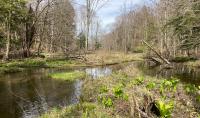
The Seneca Division is marked by the Muddy Creek drainage, which flows northwest into French Creek and has a floodplain of about 5,000 feet wide. The Muddy Creek drainage has a relatively flat gradient with tight looping creek channels and numerous oxbows/cutoffs.
The Muddy Creek sub-basin contains Muddy and Dead Creeks, which flow to the northwest to join with French Creek. Creek discharges during the year at Erie NWR follow a classic snowmelt runoff pattern with highest flows in early spring, occurring in March and April as snow melts and rainfall adds to peak stream flows. Water levels fall steeply to a low in August when stream flow begins to climb again.
Fluvial Features: Meanders & Oxbow Lakes
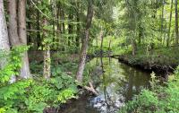
One of Muddy Creek's most noticeable features are its many meanders and oxbow lakes. These meanders bend, curve, or loop along the flat valley bottom, and do so to maintain their equilibrium, in an effort to move water and sediment efficiently downslope.
Zoom in on the map to your right to see if you can identify these two fluvial features!
The Muddy Creek--Dead Creek stream valley is an area of high biological diversity, supporting uncommon and diverse natural communities and rare plants and animals. One reason for this rich diversity is the meandering nature of Muddy Creek that, over time, has created microhabitats within its broad floodplain.
Meanders are produced when water in a stream channel erodes the sediments of an outer bend of a streambank and deposits those sediments on subsequent inner bends downstream. These features are referred to as cut-banks and point bars, respectively. This process reinforces the riffle-pool structure of a stream.
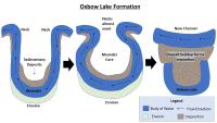
When the bends of two meanders meet, they bypass the curve of the river at the neck, creating an oxbow lake which becomes isolated, and can be infilled with overwash sediment. As oxbow lakes are stillwater lakes, with no current flowing through them any longer, the entire lake gradually silts up, eventually becoming a bog or swamp.
QUIZ: Can you identify any oxbow lakes on the map that appear to have filled in entirely with vegetation?!
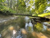
The Importance of Large Woody Debris
Large woody debris, or "LWD" for short, is typically described as fallen trees, logs, sticks, root wads, and branches at least 4 inches wide and 6 inches long in size that are in contact with stream water.
Traditionally, large buildups of wood, also known as log jams are removed from stream systems by humans in an effort to clean up stream channels, reduce hazards to boaters and kayakers, and to prevent localized flooding.
The presence of LWD, however, also brings many physical and biological benefits to stream systems. The presence of woody material helps connect stream channels to their floodplains, by acting as obstacles in the creek channel which redirect high flows into adjacent floodplains during spring snow melts and heavy rainstorm events. This actions transfers sediment and nutrients into floodplain systems, and allows floodplains to act as sponges that capture excess water, sediment, and nutrients. This process also reduces the amount and rate at which floodwaters move downstream, which reduces erosion of creek banks, improves water quality, and protects communities situated downstream.
Large woody debris also create diverse aquatic habitats. Exposed logs above water act as perching sites for birds and as sunbathing sites for reptiles, like the midland painted turtle (Chrysemys picta marginata). Submerged LWD creates refugia or hiding places for fish, like brook trout (Salvelinus fontinalis), among other aquatic organisms. Large woody debris can cause scouring of the stream bed and along banks downstream, which form pools and shaded, undercut banks that many aquatic organisms use for shelter and rest.
Snags and submerged logs are among the most productive habitat structure for macroinvertebrate colonization. Large woody debris help increase aquatic biodiversity, by providing a surface for algae, detritus, and aquatic plants to settle on. This process provides habitat and food for a variety of aquatic macroinvertebrates, which, in turn, serve as important food sources for fish populations.
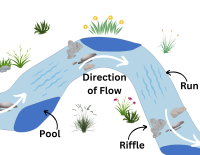
Stream Anatomy - Riffles, Runs, and Pools
Muddy Creek, like most perennial streams, features a mixture of flows and depths which provide a variety of habitats to support fish and invertebrate life. These flow and depth regimes are lumped into 3 groups or microhabitats: riffles, runs, and pools. Each habitat has unique properties that allow for a diversity of organisms to exist and thrive.
RIFFLES
Riffles are areas in the stream that have water turbulence, often caused by rocks or other debris in the water. Riffles are shallow places where water runs fast and is agitated by rocks. Due to their shallow nature, riffles are where oxygen is importantly mixed into the water.
Only animals that cling very well, such as net-winged midges, caddisflies, stoneflies, some mayflies, dace, and sculpins can spend much time here, and plant life is restricted to diatoms and small algae. Many macroinvertebrates have adapted to this turbulent lifestyle by cementing themselves down to cobbles and other large rocks, so as to not get swept downstream.
RUNS
A run is a stretch of smooth, unbroken, slower-moving water that make up the majority of the stream system. The smooth surface allows for light to penetrate, allowing certain aquatic plants to grow. Runs are typically deep, occurring between bends, and are usually found downstream of pools, and upstream of riffles.
Fishes, like minnows, that are too small to compete for prime pool habitats often end up in runs.
POOLS
Pools are areas of deep water, with little to no water movement. These areas can be found in the bends of rivers and creek, along the inside wall of the turn, also referred to as a cut-bank. When stream waters meet up with a large fallen log, a set of boulders, or other impediments, water pours over the top. The vertical force of water cascading down the other side of these obstacles eventually carves out a pool through the process of erosion.
Pools are prime-real estate for a variety of aquatic organisms, and are favorite places for trout, and other fish species, to feed and use as refugia from predators. As the water in pools flows a little slower, some other animals do well here, including freshwater mussels, snails, and worms. One of the benefits to slow-moving water is that organic debris settles out into it. Another advantage pools provide is that organisms don't have to relocate to another area if/when stream water levels drop.
Riffles and runs are critical for maintaining a variety and abundance of insects in most high-gradient streams and serving as spawning and feeding refugia for certain fish. Riffles and runs offer a diversity of habitat through variety of particle size, and, in many small high-gradient streams, will provide the most stable habitat.
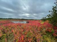
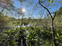
A Story of Wetlands
Wetlands make up a large part of the Muddy Creek watershed and the Seneca Division, which supports various habitat types, including streams, floodplain forests, bottomland swamps, emergent wetlands, fens and seeps, mixed hardwood and softwood forest, grasslands, shrublands, as well as abandoned orchards, pine plantations, and croplands.
Muddy Creek supports rare freshwater mussels and fish, and abundant scrub-shrub and forested wetlands in riparian areas as well as a rare shrub fen community. The Dead Creek riparian system contributes extensive marsh habitat and supports rare plants and fish habitats. The riparian system created by Muddy Creek and Dead Creek contains numerous types of forested, scrub-shrub and emergent wetlands characteristic of the glaciated region of northwest Pennsylvania.
Emergent Herbaceous Wetlands
The refuge includes over 621 acres of natural emergent marsh in both the Sugar Lake and Seneca Divisions. An emergent marsh is a type of shallow-water wetland that is frequently or continually filled with water, containing vegetation, such as cattails (Typha spp.) or bulrushes (Schoenoplectus spp.) that have adapted to wet soil conditions.
Other common plants in these habitats include water plantains (Alisma spp.), spike-rushes (Eleocharis spp.), sedges (Carex spp.), arrowheads (Sagittaria spp.), smartweeds (Persicaria spp.), rice cut grass (Leersia oryzoides), floating vegetation like duckweed (Lemna spp.) and yellow pond-lily (Nuphar advena), and submerged aquatic plants like common waterweed (Elodea canadensis) and bladderworts (Utricularia spp.). Click the link below to learn more about some of these species .
Marshes often consist of distinct zones, ranging from areas with saturated soils to areas that are permanently inundated. Along the drier margins of the emergent marsh, grasses and sedges typically dominate. In deeper, open water areas, aquatic vegetation dominates. Water levels in the natural emergent marsh areas throughout the refuge are dictated by weather and beaver activity and can range from mudflats to two to three feet of water.
Emergent marshes provide critical habitat for waterfowl, wading birds, and many other wetland species, including the Virginia rail, sora, common moorhen, American and least bitterns, and pied billed grebes. Other birds heard or observed on marsh bird surveys include sedge and marsh wrens, common yellowthroat, belted kingfisher, and red-winged blackbird.
Wet Shrublands
Wet shrublands occur along streams and rivers throughout Western Pennsylvania. This habitat makes up a total of 1,157 acres on the refuge. Shrubs range from 1.5–3 meters in height, usually forming at least a 25–50 percent cover.
Silky dogwood, winterberry, highbush blueberry, red osier dogwood, white meadowsweet, and black willow dominate these areas. Along Muddy and Dead Creeks, native dogwoods and willows dominate wet shrublands in the Seneca Division.
Wildlife that utilize wet shrublands include the willow flycatcher (Empidonax traillii), Canada warbler (Cardellina canadensis), blue-winged warbler (Vermivora pinus), American woodcock (Scolopax minor), American mink (Neogale vison), and muskrat (Ondatra zibethicus).
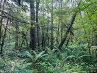
Forested Wetlands
Forested wetlands make up about 16 percent of the refuge (1,458 acres). There are two kinds of forested wetlands that appear on the refuge: swamp forest and broadleaf-conifer swamp.
Swamp forest communities occur in temporarily flooded or saturated soils throughout the growing season. Historically these areas contain eastern hemlock, yellow birch, American beech, white pine, black ash, and red maple.
The forested wetland habitat along Muddy Creek is dominated by red and silver maple, white ash, shagbark, and bitternut hickory. These forests can be interspersed with vernal pools. Areas of forested wetland on the refuge provide large contiguous areas for species of conservation concern, such as the Cerulean Warbler (Setophaga cerulea), Louisiana Waterthrush (Parkesia motacilla), Spotted Turtle (Clemmys guttata), and several species of bats.
Recreational Opportunities
Hiking, Wildlife Observation, and Photography
Wildlife observation, including the observation of plants and other natural features, is one of the most popular recreational uses of the refuge. The refuge is a designated Watchable Wildlife site with over 6 miles of maintained trails , including Tsuga, Beaver Run, and Deer Run on the Sugar Lake Division and Muddy Creek Holly and Trolley Line trails on the Seneca Division.
Hunting & Fishing
Hunting and fishing are two of the six priority public uses outlined in the Refuge System Improvement Act of 1997. The Service supports and encourages priority uses when they are compatible on NWR lands. Hunting is used in some instances to manage wildlife populations.
Hunting and fishing are traditional recreational uses of renewable natural resources deeply rooted in America’s heritage, and they can be an important wildlife management tool.
The refuge’s hunting and fishing program provide a high-quality recreational experience on refuge lands and waters, expand opportunities and access for hunters and anglers including youth, disabled people, and other underrepresented groups, and promote stewardship of our shared natural resources.
For full details regarding hunting and fishing on the refuge, along with Findings of Appropriateness and Compatibility Determinations, please refer to the refuge's 2023-2024 Hunting Regulations and see the 2022 Erie NWR Hunting and Recreational Fishing Plan .
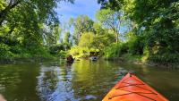
Non-motorized boat use (kayaking, canoeing, paddleboarding)
The dynamic and natural state of Muddy Creek features hazardous log jams, which occur frequently along most of the length of the creek. Due to this danger, and Muddy Creek's importance as critical stream habitat for threatened and endangered freshwater mussels, the refuge does not allow the use of boats, kayaks, or other non-motorized watercraft along the creek.
The public, however, are able to view the refuge up-close along the 1-mile portion of French Creek which borders the northwest end of the Seneca Division. This segment of the French Creek follows the French Creek Water Trail , a recreational and educational corridor between specific locations that can be used for both single day and multiple day trips.
The French Creek Water Trail, produced by our partners at the French Creek Valley Conservancy, provides information on popular public access points located off and along the French Creek, including access points, kayak/canoe launch sites, day use sites, and even overnight camping locations.
For more information on the Upper French Creek Water Trail, click here .
For more information on the Lower French Creek Water Trail, click here .
Freshwater Stream Ecosystems
Freshwater stream ecosystems in northwest Pennsylvania are diverse and dynamic, supporting a rich array of aquatic life. These ecosystems are characterized by a variety of physical and chemical factors, including water flow, temperature, and nutrient levels. The food webs within these streams and surrounding wetlands are complex and interconnected, showcasing the interdependence of different organisms.
The diagram above displays the organisms one might encounter in a typical freshwater stream in Northwest Pennsylvania.
At the base of the food web are primary producers such as algae, diatoms, and aquatic plants, which use sunlight to convert energy into organic matter through photosynthesis. These primary producers form the foundation for the entire ecosystem. Equally important are the decomposers, including fungi and bacteria, which breakdown decaying plant and animal material, recycling nutrients back into the system. Herbivores, including insects and small invertebrates feed on the primary producers, while serving as prey for larger organisms.
Streams are inhabited by a diverse range of fish species, including brook trout, American pickerel, various minnows, and darters. These fish play a crucial role as both predators and prey, contributing to the overall balance of the ecosystem. Aquatic insects, such as mayflies, caddisflies, and stoneflies, are abundant and form a significant portion of the diet for many fish species.
The food web also includes secondary consumers, such as larger predatory fish, turtles, amphibians, and water-dwelling insects. Birds, like kingfishers and herons, are common predators in these ecosystems, feeding on fish and aquatic invertebrates. Terrestrial organisms, like spiders and beetles, also contribute to the food web when they fall into the water.
In the sections below, we will highlight many of the organisms one might encounter in the wetlands and streams of the Muddy Creek basin, touching upon several aquatic plants, macroinvertebrates, mussels, fish & more !
Aquatic & Wetland Vegetation
Highlighted below are some of the aquatic and wetland vegetation species found within the Muddy Creek basin.
Aquatic Macroinvertebrates: Stream Bioindicators
Aquatic macroinvertebrates are insects in their nymph or larval stages, snails, worms, and crayfish that spend at least part of their lives in water. Macroinvertebrates are named as such because they are large enough to see without a microscope.
Aquatic macroinvertebrate communities are strongly influenced by their surrounding environment, and act as bioindicators for the overall condition or health of freshwater ecosystems.
Macroinvertebrates play a key role in aquatic food webs as they are primary processors of organic materials, recycling nutrients back into aquatic systems. Some studies have suggested that aquatic macroinvertebrates are responsible for processing up to 73% of the riparian leaf litter that enters a stream (Covich et al. 1999). They are also major food sources for higher trophic levels. Macroinvertebrates are often food generalists and have therefore been classified into groups called functional feeding groups.
The 5 major functional feeding groups are:
A mayfly larva, of the Order Ephemeroptera found in Woodcock Creek. The mayfly larva are an example of a collector. Credit: USFWS
- Scrapers (or grazers), which consume algae and associated material. Grazers are found on rocks and woody debris. Included in this group are water beetles and snails.
- Shredders, which consume leaf litter, woody debris, and other coarse particulate organic matter (CPOM). Included in this group are caddisflies, crane flies, and stoneflies.
- Collectors (gatherers), which collect fine particulate organic matter (FPOM) from the water column and stream bottom. Included in this group are true flies, mayflies, crayfish, clams, mussels, and aquatic earthworms.
A dark fishfly larva, of the Genus Nigronia. Dark fishflies are an example of a predator. Credit: USFWS
- Filterers, which collect FPOM from the water column using a variety of filters. Included in this group are blackflies and net spinning caddisflies.
- Predators, which feed on the 4 feeding groups (consumers) listed above. Included in this group are stoneflies, dragonflies, damselflies, dobsonflies, water beetles, and leeches.
In the interactive screen below, hover above groups of freshwater macroinvertebrates to learn more about individual species and their diagnostic characteristics!
Credit: Macroinvertebrates.org
The Crown Jewels of Muddy Creek are its Abundant & Diverse Aquatic Life
A diverse assemblage of aquatic organisms found within the Muddy Creek watershed, in order from left to right: Mottled sculpin (Cottus bairdii), a Cambarid crayfish (Family Cambaridae), Fatmucket mussel (Lamsilis siliquoidea), Logperch (Percina caprodes), and Rainbow darter (Etheostoma caeruleum). Credit for Images 1, 3, 4, & 5: Alejandra Lewandowski; Image 2: USFWS.
A collage highlighting several of the freshwater mussel species found within Muddy Creek. Credit: Y. Laskaris/USFWS
The portion of Muddy Creek that flows through the Seneca Division provides habitat for 22 species of freshwater mussels, including the federally endangered Northern riffleshell, rayed bean, snuffbox, clubshell, the federally threatened rabbitsfoot and longsolid, and several state-listed and globally rare species. Muddy Creek appears to be second only to the main stem of French Creek in providing habitat for the most diverse assemblage of freshwater mussels in Pennsylvania (WPC 2004).
There are 60 species of fish found in Muddy Creek and its tributaries. These include at least 45 species reported to serve as freshwater mussel hosts, and two of 34 Pennsylvania state-listed fish species (Haynes and Wells 2006, PFBC 2018). These host fish species are critical to the successful reproduction of many of the rare freshwater mussel populations, carrying the mussels’ glochidia larvae during a critical development period (Haynes and Wells 2006). Many of these host fish are darter species, including the rare eastern sand darter which was rediscovered in 1991.
DID YOU KNOW? Freshwater mussels are the most endangered group of organisms in the United States. Of the 303 species known to exist in North America, over 70% are considered endangered, threatened, or of special concern.
Mussel Life Cycles & Life History Strategies
A diagram of the lifecycle for freshwater mussels showing how larva from a fertilized adult female needs to use a host (fish gills) in order to metamorphose or transform into a juvenile adult. Without this parasitic stage juvenile, thus adult mussels would not be created. (John Megahan/University of Michigan)
Awe-Inspiring Adaptations
One of the most fascinating things about freshwater mussels are the variety of life history strategies mussel species have evolved to attract host fish to take up their larva. To get their glochidia into a fish's gills, mussels require luring fish hosts close to their bodies. Many species have evolved lures that mimic food items that host fish are attracted too, including minnows, crayfish, flies, and worms.
Other species, like members of the Genus Epioblasma, which includes the snuffbox (Epioblasma triquetra), have evolved to clamp their valves shut on the heads of fish that mistake them for stones while searching for food items on the stream bottom.
Some species, like the scaleshell (Leptodea leptodon), even go so far as to sacrifice their lives for reproduction, by unburying themselves, lying on the top of the substrate, and offering their bodies on a silver platter to be eaten whole by fish. In this extreme example, the fish chomps down on the female, and the larvae the female was holding inside are then released into the fish's gills.
A largemouth bass attacks a Plain Pocketbook (Lampsilis cardium) displaying it's mantle lure, which strikingly resembles a minnow. Contact with the female mussel's mantle lure triggers the release of hundreds of juvenile larvae (glochidia) into the gills of the unsuspecting bass. Video by Brett Billings and Ryan Hagerty/USFWS.
Wavy-rayed lampmussel (Lampsilis fasciola)
The wavy-rayed lampmussel is found in smaller, upstream creeks or in downstream areas of larger rivers. The species can be found in sand and gravel bottoms in riffles and rapid waters.
The wavy-rayed lampmussel grows up to 4 inches in length, and is rounded or oval in shape. The shell is fairly thick, and smooth, with yellow to yellow-brown coloration and thin wavy green rays.
Female Lampsilis fasciola have a distinct mantle flap which resembles a minnow or darter. The mimic fish lures its host fish, which chews on the flap and breaks the membrane of the gills. As a result, the fish is infected with glochidia.
The mantle flap of the Wavy-rayed lampmussel (Lampsilis fasciola) resembles a minnow.
Can't get enough of the amazing lives of freshwater mussels?!
Click the links below for additional information on freshwater mussels, their ecological and cultural value, evolutionary relationships with fish, and the enormous biodiversity of species found across North America.
The stories below highlight habitat restoration efforts, and the work performed by National Fish Hatcheries to raise and stock freshwater mussels to be released as part of population recovery. The U.S. Fish & Wildlife Service is also collaborating to 3D print freshwater mussels for research and education!
Wetlands Supporting Wildlife
Research & Monitoring
The Refuge performs several inventory and monitoring projects to understand the health of forests, streams, wetlands, and the wildlife populations. Use the slideshow below to learn more about some of these projects!


