25th Anniversary of the Boundary Waters Canoe Area Blowdown
The storm occurred midday on Sunday, July 4, 1999 with the most extensive damage occurring between noon and 1 pm.
Jonathan Wolfe
Map of Northeast Minnesota
Shows where the most intense damage occurred in the BWCAW relative to Northeast Minnesota.
Graphic shows where the most intense damage occurred (red areas on the inset graphic). The inset graphic is positioned to align geographically with the broader satellite image.
The Storm
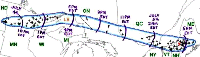
The Boundary Waters Canoe Area Wilderness (BWCAW) blowdown was a small part of a much larger event.
Area affected by the July 4-5, 1999 derecho event (outlined in blue). Curved purple lines represent the approximate locations of the gust front at three-hourly intervals. "+" symbols indicate the locations of wind damage or estimated wind gusts above severe limits (58 mph or greater).
The map above shows the impressive length of this storm stretching from its origins in North Dakota and reaching all the way to Maine.
The July 4th, 1999 Boundary Waters Blowdown was caused by a Derecho (pronounced like "deh-REY-cho"). A derecho, by definition, is defined by a swath of wind damage that extends at least 400 miles (about 650 kilometers), is at least 60 miles (about 100 km) wide, includes wind gusts of at least 58 mph (93 km/h) along most of its length, and also includes several, well-separated 75 mph (121 km/h) or greater gusts. Here are the storm highlights:
Active for 22 hours
Traveled 1,300 miles (North Dakota to Maine)
60 mph average forward speed
4 Deaths (none in Minnesota)
>70 Injuries (~30 in Minnesota)
>$100,000,000 in damage ($189 million in 2024 dollars)
>700,000 without power U.S. and Canada
American Museum of Natural History Short Documentary on the Boundary Waters Blowdown.
The Hardest Hit Area
The most intense damage started near Newton Lake on the western edge and ended near Seagull Lake on the eastern side which encompasses the "heart" of the Boundary Waters Canoe Area.
66-100% Blowdown Area
The area that was hardest hit (67-100% damage area) is shown in red in the above graphic.
Various pictures of trees blown down from the storm.
Damage Photos
Mapped Points of Interest
01 / 08
1
Start of Largest Swath of Intense Damage
2
Swath of trees down near Ely, MN
Location Approximated
3
Radar as it crosses Snowbank lake
4
Footprints of the Cavity Lake and Ham Lake Fires
The 1999 blowdown caused the damage that provided the fuel for two large forest fires - the Cavity Lake Fire (2006 - 32,000 acres) and the Ham Lake Fire (2007 - 75,000 acres). The evidence of these fires is still visible on the satellite map.
5
Damage Along the Gunflint Trail
6
The Seagull Lake Guard Station
7
End of Largest Swath of Intense Damage
8
Gunflint Lake Cabin
The damage extended into other sections of the Superior National Forest too. This photo was taken on the south shore of Gunflint Lake
Radar Loop
Four-hour "ping-pong" animation of NWS Duluth base reflectivity radar data showing progress of the July 4, 1999 derecho-producing bow echo system across north central Minnesota through midday, and its subsequent movement across the "Arrowhead" region during the early afternoon. Reflectivity intensity scale at left (dBZ).
Radar imagery showing warm front lifting north as the Mesoscale Convective System (MCS), travels along and ingests the moisture along this gradient. This MCS eventually became known as a derecho as it continued its trek all the way to Maine.
Satellite Loop
Infrared satellite showing the storm evolution
Infrared satellite imagery loop showing the storm evolution. The blue and purple colors show cold cloud tops which is indicative of stronger convection and storm strength.
Derecho Formation
Formation of derecho step 1
Formation of a derecho step 2. Ascending air cloud growing and tilting.
Formation of a derecho step 3, ascending front to rear flow increasing with increasing downward flow progressing forward causing the rainfall reflectivity to bulge or bow out and accelerate in the center of the line of storms. This rain-cooled air spreading out rapidly along with damaging thunderstorm winds at the surface.
A cluster of thunderstorms creates a cold pool (pool of rain-cooled air that has higher density than the surrounding environment) that spreads out as it hits the earth's surface. This generates a gust front that, under the right atmospheric conditions, continues to ingest more warm and moist air fueling further convection. As the cold pool continues to strengthen, the cluster of storms begins to propagate with the overall atmospheric wind. This balance between incoming warm, most air and storm speed creates a steady-state cycle that will continue to grow the cluster in scale and propagate the storm downwind. Meanwhile, stronger winds aloft run into this complex and momentum from the strong winds gets transferred downward causing downbursts or microbursts along its track. This cycle will continue until the storm runs out of warm and moist air ahead of the system or the atmospheric conditions become unfavorable for this balance to continue.
Scales wind damage
The terminology that defines the different scales of damage.
Derecho Climatology
Derecho Warm Season Climatology Map
Derecho Warm Season Climatology -Approximate number of times "moderate and high intensity" derechos affected points in the United States during the years 1980 through 2001. Areas affected by 3 or more derecho events are shaded in yellow, orange, and red (modified from Coniglio and Stensrud 2004).
Derecho annual climatology
Derechos in the United States are most common in the late spring and summer (May through August), with more than 75% occurring between April and August (see graph above).
Meteorological Set-Up
The meteorological set-up of the BWCA blowdown
Winds aligned throughout the vertical axis of the atmosphere to move the storm complex east over a large dome of high pressure that existed over the Ohio River Valley. Meanwhile a shortwave vorticity maxima, as seen in the top left panel of this graphic, aided in the formation of the original thunderstorms. It's subtle, but a surface boundary existed with an orientation of west to east along an inverted surface low pressure trough near Lake Superior.
Upper air analysis from International Falls, MN
The upper air wind profile has a linear shape with very little instability north of a quasi-stationary front.
Upper Air Sounding for Minneapolis
South of the quasi-stationary front, the air mass is more primed for convection with up to 2000 J/kg of Convective Available Potential Energy (CAPE) and a more chaotic hodograph.
The Original July 4 Blowdown
The original July 4th blowdown
July 4th seems to be a popular date for large blowdowns in the north woods. July 4, 1999 was not the first time that a blowdown occurred. Back in 1977, a large blowdown happened in central Minnesota and northern Wisconsin. This map was created by Ted Fujita who created the now famous Fujita scale which measures the strength of a tornado based on its damage. As you can see above, there are large swaths of damage from this straight line wind event that would be similar to what an "F2" tornado (113-157 mph winds) would cause.
Graphic shows where the most intense damage occurred (red areas on the inset graphic). The inset graphic is positioned to align geographically with the broader satellite image.
The map above shows the impressive length of this storm stretching from its origins in North Dakota and reaching all the way to Maine.
The area that was hardest hit (67-100% damage area) is shown in red in the above graphic.
Damage Photos
Radar imagery showing warm front lifting north as the Mesoscale Convective System (MCS), travels along and ingests the moisture along this gradient. This MCS eventually became known as a derecho as it continued its trek all the way to Maine.
Infrared satellite imagery loop showing the storm evolution. The blue and purple colors show cold cloud tops which is indicative of stronger convection and storm strength.
The terminology that defines the different scales of damage.
Derecho Warm Season Climatology -Approximate number of times "moderate and high intensity" derechos affected points in the United States during the years 1980 through 2001. Areas affected by 3 or more derecho events are shaded in yellow, orange, and red (modified from Coniglio and Stensrud 2004).
Derechos in the United States are most common in the late spring and summer (May through August), with more than 75% occurring between April and August (see graph above).
Winds aligned throughout the vertical axis of the atmosphere to move the storm complex east over a large dome of high pressure that existed over the Ohio River Valley. Meanwhile a shortwave vorticity maxima, as seen in the top left panel of this graphic, aided in the formation of the original thunderstorms. It's subtle, but a surface boundary existed with an orientation of west to east along an inverted surface low pressure trough near Lake Superior.
The upper air wind profile has a linear shape with very little instability north of a quasi-stationary front.
South of the quasi-stationary front, the air mass is more primed for convection with up to 2000 J/kg of Convective Available Potential Energy (CAPE) and a more chaotic hodograph.
July 4th seems to be a popular date for large blowdowns in the north woods. July 4, 1999 was not the first time that a blowdown occurred. Back in 1977, a large blowdown happened in central Minnesota and northern Wisconsin. This map was created by Ted Fujita who created the now famous Fujita scale which measures the strength of a tornado based on its damage. As you can see above, there are large swaths of damage from this straight line wind event that would be similar to what an "F2" tornado (113-157 mph winds) would cause.