
Clear Waters
Tracking Change in Sierra Nevada Lakes
National parks in the Sierra Nevada protect over 1,200 lakes. Mountain lakes provide habitat for wild plants and animals and supply fresh water to downstream farms and communities. Their rugged settings and clear blue water make them popular hiking destinations.
What does it take to understand how lakes are changing?
Join Sierra Nevada Network field scientists as we travel to remote areas and study lake ecosystems. The information we gather will help stewards make the best science-based decisions for our national parks .
Welcome to the Sierra Nevada
The Sierra Nevada is beloved by people from around the world. The mountain range runs from the Mojave Desert to the Cascades in northern California, over 250 miles.
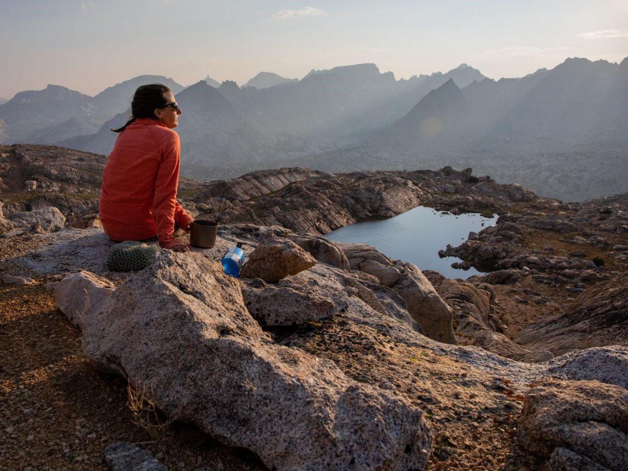
Sunset on the Great Western Divide
It is in the highest elevations—the subalpine and alpine—where we hike for days to visit some of the most beautiful lakes in the country. However, visitors and park staff are noticing changes in these clear, cold waters.
These lake basins have been naturally carved by water, ice, and snow.
National Parks and a Changing Watershed
Sierra Nevada lakes are the headwaters for much of California’s water supply. Many of these lakes are in remote wilderness areas protected by the U.S. Forest Service and the U.S. National Park Service .
Click or tap on the light green areas of the map to learn more about specific wilderness areas.
Lakes in Sequoia and Kings Canyon National Parks and Yosemite National Park have some of the purest water quality in the world. Despite the protection provided by national parks, these lakes are sensitive to changes in the environment.
How and why are lakes changing?
Long, stringy filamentous algae may be appearing more frequently than in the recent past.
Air pollution, climate change, and the spread of invasive species all threaten the health of mountain lakes. Elements like nitrogen—which comes from agriculture, industry, and transportation—reduce water clarity and promote the growth of algae.
Sierra Nevada lakes have evolved with low nutrients and long seasons of ice and snow. The input of nutrients into a remote environment can be like adding fertilizer to a garden. But excess nutrients can harm plants and animals that thrive in low nutrient environments.
Changes in nutrients and algae have effects on the larger food web.
As the climate changes, lakes are further threatened by reduced ice and snow. During warmer-than-average winters, lake ice forms later in the season and melts sooner. More ice-free days may allow more time for algae to grow.
How can park managers get the information they need about changes in mountain lakes?
Tracking Change with the Sierra Nevada Network
The Sierra Nevada Network is one of 32 National Park Service Inventory and Monitoring programs. We gather and analyze information to understand the ecological health of parks. Our science helps managers care for our parks, so that future generations can enjoy and learn from them as we do.
We study changes in lakes, bird populations, wetlands, rivers, climate, and forests.
In this story, you will join field scientists as they gather information about mountain lakes.
Click or tap the white dots on the map to explore lake sampling locations. Zoom in to take a closer look.
Each summer, we hike deep into the wilderness to collect data in three national parks. Some of these sites are so remote that they can take days to reach. Because we can't visit every lake, we use statistics to select 76 lakes that give us a good idea of what is happening over space and time.
Join an Inventory and Monitoring Field Crew
During the spring months, Sierra Nevada Network staff get ready for the field season and build our teams. These teams are made up of passionate scientists and backpackers eager to use their skills to collect data in national parks.
With the arrival of summer, we are ready to get started. We jump into training before setting off into remote areas of the parks to begin collecting data.
Keep scrolling to join our team, start training, and prepare for the first field tour.
Train at Aster Lake
Training involves getting familiar with safety procedures, boat techniques, and lake sampling methods. Part of the training includes an overnight trip to Aster Lake in Sequoia National Park.
During training, we learn how to:
Use the links above to see where different activities occur. Click or tap the points on the map for more information.
Get Ready for the Field Tour
Welcome to our first multi-day backpacking trip. We have a lot to do to get ready, including planning the route and packing gear. Our food, overnight camping gear, and scientific equipment needs to fit into large backpacks that we carry into the wilderness.
Scientific equipment includes inflatable boats, water filters, and temperature sensors.
Safe backpacking involves good communication and teamwork. We look out for each other and make sure everyone is safe and healthy throughout the trip. We work hard to maintain our strength and fitness, and learn to talk to each other about our limitations.
"For me, getting to move my body all day long is such a gift. I love how physical this work is, and how it takes us over passes, across cross-country routes, and up to lake basins that have rarely been visited." Talia Chorover, Field Scientist and Crew Lead
Field scientists Talia Chorover (above and main photo, left) and Marisa Monroe (main photo, right) are ready to lead us on the first field tour of the season.
Continue scrolling to start the trip.
Four Lakes in Sequoia National Park
Our journey takes us to four high elevation lakes: Sky Blue, Little South America, a lake at Upper Kern, and a lake at Kern Point
Click or tap on map points to see lake details.
We enter Sequoia National Park from the dramatic eastern side of the Sierra Nevada.
Jagged peaks and extreme vertical changes are common on the eastern side of the parks.
The route travels through deep canyons and across high mountain passes. We hike over sixty miles in six days, beginning at an elevation of almost 10,000 feet and climbing above 12,000 feet.
A trail profile helps us visualize the terrain.
At each lake, we collect and filter water samples, gather information on amphibians, and study algae growth. This story will highlight each of these activities during the trip.
Are you ready to start the first day?
Day 1: Cottonwood Pass to Sky Blue Lake
Today's goal is to reach Sky Blue Lake, which is about 14 miles from our start point. We begin after sunrise at the Cottonwood Pass trailhead in Inyo National Forest .
- Click or tap a symbol to learn more about today's points of interest
- In a symbol's pop up box, select "Zoom to" to get a closer look at the location
- Try panning or zooming around the map to explore on your own
The trail starts at an elevation of almost 10,000 feet and climbs to Cottonwood Pass at 11,200 feet. Near the top of Cottonwood Pass, we pause at the junction of the Pacific Crest Trail , a popular National Scenic Trail that runs from Mexico to Canada.
Cross Cottonwood Pass
Next, we head away from the trail through Miter Basin, a beautiful bowl of granite that holds several lakes. Off-trail navigation can be challenging: we scramble up granite slopes and find our way across rocky terrain.
Navigate off-trail through Miter Basin
After a full day of hiking, we arrive at Sky Blue Lake. We end our day by setting up our campsite and settling in for a peaceful evening. Sunset fills the Miter Basin with changing hues of pink and red until finally, a spectacular night sky unfolds.
Set up camp at Sky Blue Lake
Congratulations on finishing the first day. Tomorrow, we will sample Sky Blue Lake.
Day 2: Survey Sky Blue Lake and Hike to Crabtree Basin
Sky Blue Lake is the largest lake on our trip at 42 acres. The work starts early in the morning at the outlet, or lowest stream flowing out of the lake. Here we collect water samples and use sensors to measure water temperature, pH, specific conductance, and dissolved oxygen.
Several of the water samples need to be filtered while we are still in the field. Water chemistry labs use specific methods to analyze our samples. Some methods require the use of unfiltered water, while others require filtered water.
Click or tap play on the right to see a filtering time-lapse video.
We use lab results to measure change over time and look at nutrient patterns across the parks. The map below shows the concentration of nitrogen ions, or nitrate, measured at lake sites in Sequoia National Park between 2011 and 2018.
Nitrate concentrations are often higher in lakes or watersheds that have little vegetation and/or a higher percentage of steep, north-facing slopes.
We pack up the bottles of water to be sent to a lab for analysis. After a morning of sampling, we continue through the Miter Basin toward Crabtree Pass.
Crabtree Pass presents a steep descent through loose rock.
“One of the most memorable moments for me during this trip was descending through Crabtree Basin. We were exhausted, but the light was amazing and every angle revealed a new aspect of beauty...” Marisa Monroe, Field Scientist
We descend into Crabtree Basin and find a place to camp for the evening. The night sky opens above, with the Perseid meteor shower on full display.
Day 3: Crossroads to Little South America
The next morning, we break camp and pick up supplies at Crabtree Ranger Station. Wilderness rangers play an important role in remote parts of the parks. Based out of primitive cabins or tent platforms, rangers support communication and safety for travelers.
Pick up supplies at the Crabtree Ranger Station
Today we travel 12 miles to reach a small lake—nicknamed Little South America—that rests downstream of Lake South America. Part of the day takes us along the busy John Muir Trail . Most hikers are heading south to climb nearby Mount Whitney, the tallest peak in the lower 48 states at 14,500 feet. After a few miles, we head north on a less traveled route.
Hike north toward Bighorn Plateau
Bighorn Plateau is a wide tableland of relatively flat terrain bordered by high mountains. We pause to catch our breath and take in our surroundings.
"The Bighorn Plateau is one of my favorite places in the whole park. The 360 degree views of the peaks that fringe this wide open plateau are mesmerizing." Talia Chorover, Field Scientist and Crew Lead
Trek across Bighorn Plateau
Finally, we reach the pass above Little South America and drop over the ridge and into the lake basin. After a long day, we find a camping spot as the sun goes down over the Great Western Divide.
Rest and recharge at Little Lake South America
Day 4: One Day, Two Lakes
The goal today is to visit two lakes. We survey Little South America before heading cross-country to an unnamed lake near the headwaters of the Kern River . The Kern River is a 150-mile long Wild and Scenic River that drains into the San Joaquin Valley .
The lake in the Upper Kern area is one of many lakes that have never been officially named.
At each lake, we collect data about amphibian populations. We are particularly interested in yellow-legged frogs (Rana sierrae and Rana muscosa). Yellow-legged frogs once thrived in the Sierra Nevada, but have since disappeared from 92% of their historic range.
Sierra Nevada Yellow-legged Frog, Rana sierrae.
What happened to yellow-legged frogs? First, trout were introduced to bolster tourism in lakes where fish have never lived. Trout created an imbalance in the food web by eating tadpoles, young frogs, and insects. Second, the frogs are being killed by a fungal disease called chytridiomycosis, also known as chytrid fungus or Bd.
Mountain Yellow-legged Frog, Rana muscosa.
We spend an hour counting frogs along the shoreline of the lake and in nearby wetlands, ponds, and streams. Frog observations support several park projects that focus on the conservation and recovery of these species. You can learn more at the Yosemite National Park and Sequoia and Kings Canyon National Parks web pages.
We have finished the fourth day. Tomorrow, we will head to Kern Point to visit the final lake.
Day 5: Kern Point
Kern Point is an isolated ridge that rises above the Kern River canyon. The route takes us off-trail and up a steep canyon wall, where we navigate loose rocks and soft, crumbly soil. The climb is arduous, but we reach Kern Point mid-morning and start surveying the 25-acre lake.
“If there is a place that symbolizes the grittiness of the job, it's Kern Point. Our challenge was 1.5 miles of steep uphill, followed by a cold sampling session as thunderclouds were looming... it was beautiful. The lake is an infinity pool overlooking the far reaches of the wilderness.” Glauco Puig-Santana, Field Scientist
The lake at Kern Point is perched at 11,500 feet and has a maximum depth of 74 feet.
The lake at Kern Point appears to be changing: we can see green filamentous algae in the lake's clear waters. Why are we so concerned about algae? One reason is that when algae die, they sink to the bottom of the lake and decompose. Decomposition takes oxygen out of the water. Without enough oxygen, creatures, such as frogs and invertebrates, cannot survive.
An expansive stretch of green algae along the lake bottom contrasts with otherwise clear water.
To look at changes in algae growth, we are partnering with scientists from Sequoia and Kings Canyon , Yosemite , and Rocky Mountain national parks, U.S. Geological Survey , Colorado State University , and the University of California on a three-year algae study.
We have been noticing green algae in lakes where historically there was none. Now we're taking a closer look.
The study sheds light on several questions about algae in park lakes:
- How common are algal blooms in mountain lakes today?
- How is algae changing? Is what we are seeing today different than the past?
- How does algae growth relate to water temperature and nutrients?
Part of our field work involves setting up algae experiments.
Field work helps answer these questions. We estimate how much green algae is on the lake bottom and in the water column, and conduct simple experiments to measure how much photosynthesis is occurring in water.
- Click or tap white points on the map to learn about shoreline surveys
- Click or tap yellow points on the map for details about productivity experiments
Before the end of the summer, we will complete algae studies for 42 lakes in the Sierra Nevada.
“These quintessential crystal-blue lakes set in granite basins are what make the high sierra feel like home for a lot of us. Green algae blooms [have been] appearing in some lakes in the past few years… These lakes are on the threshold of changing for good.” Talia Chorover, Field Scientist and Crew Lead
Day 6: End of the Trail
Today's hike takes us 17 miles out of the Kern Canyon, over Shepherd Pass, and down toward the Owens Valley. First, we cross the Kern River, which flows south through the deep, glacier-carved Kern Canyon. Each lake we visited on this trip contributes water to the Kern River.
Along the lip of the Kern Canyon, we admire the remarkable Foxtail pine (Pinus balfouriana). These long-lived trees have adapted to the cold and windy conditions of the subalpine.
Traverse the deep Kern Canyon
Shepherd Pass Trail is long and steep, climbing to 12,000 feet. This year, the pass is mostly free of the deep snowfield that can persist through late summer. We push ourselves to reach the top of the pass, where we take in the stark beauty of the landscape.
Climb to the top of Shepherd Pass
The Shepherd Pass trail drops through 6,000 feet of changing ecosystems and dramatic geology. We finish the grueling descent to the trailhead and drive into the Owens Valley, saying goodbye to the high peaks of the eastern Sierra Nevada.
Say goodbye to rugged peaks
Our journey is at an end, but the work is only beginning. After each trip, we organize field data and get it ready for analysis and reporting. We have many more lakes to visit this summer, and we're already preparing for the next trip into the mountains that we call home.
Thank you
Thank you for joining our field tour. The data we collected are part of a long term record that informs science-based decision making in national parks. Your interest is essential for preserving and protecting our parks for future generations.
For more information, check out the video below and visit our website .
Seeking Clarity: Tracking Change in Mountain Lakes
Story Map by: Monroe M and Eddy A. 2020. Clear Waters: Join a Field Crew to Track Change in Sierra Nevada Lakes . National Park Service, Fort Collins, CO. Leadership and science expertise provided by Andi Heard, Sylvia Haultain, Linda Mutch, and Jonny Nesmith. Various photos, stories, and quotes provided by Marisa Monroe, Talia Chorover, Isabel Christy, Dustin Garrison, Glauco Puig-Santana, Alex Studd-Sojka, David Barasch, Kristin Weikel, and others.


