A Mirage in the Desert
A Spatial Network Analysis of Supermarket Expansion as a Mitigator of Food Insecurity in a Formerly Redlined Neighborhood
When Houston was incorporated in 1837, it was divided into four wards, the southeast quadrant of which was known as Third Ward. In the years following the Civil War, large numbers of formerly enslaved African-Americans from east Texas and beyond settled in Third Ward and other working class neighborhoods near Houston's downtown. Third Ward eventually became the economic and cultural center of the Black community in Houston, centered around Emancipation Park, which for many years was the only park open to Blacks.
Despite being home to a number of prominent African American leaders and one of the largest Historically Black Colleges and Universities (HBCU), Texas Southern University, Third Ward has suffered from a history of disinvestment and environmental injustice.
Established in 1933 in the aftermath of the Great Depression, the Home Owners Loan Corporation (HOLC) was charged with issuing federally-backed home mortgage loans.
HOLC appraisers created residential security maps for hundreds of U.S. cities, including Houston, rating the investment potential of each neighborhood from "A: Best" to "D: Hazardous."
Neighborhoods that predominantly consisted of Blacks, Hispanics, or foreign-born immigrants were given a "D" rating and outlined in red, a practice referred to as "redlining."
Around the same time, many neighborhoods enacted deed restrictions that prevented non-White residents from moving to or purchasing property in their boundaries.
The redlined section of Third Ward was bounded by Dowling Street (now Emancipation Avenue) and Hutchins Street to the west, Leeland Street to the north, St. Bernard Street (now Cullen Boulevard) to the east, and Alabama Street to the south.
Historically, Third Ward was home to a variety of corner grocery markets, many of which had full deli and produce sections, but many of these businesses disappeared when their owners and wealthier customers left the neighborhood following desegregation to access the better schools, infrastructure, and economic opportunities of the suburbs. The eminent domain demolitions during Urban Renewal and interstate highway construction hastened the exodus of residents and businesses from Third Ward, and the crack epidemic of the 1980s further decimated the community. By the 1990s, Third Ward residents either had to rely on the energy-dense and nutrient-poor "junk food" of the remaining corner stores, gas stations, and fast-food vendors or venture outside the neighborhood to access the nearest full-service supermarkets. Today, Third Ward residents experience food insecurity at a rate 125% higher than the national average.
"Supermarket redlining" refers to the practice of large supermarkets avoiding low-income, inner-city communities of color for their store locations, or relocating their stores from these neighborhoods to the suburbs. The supermarkets justify this geographic discrimination by citing low profit margins and higher crime rates, but due to this "legal redlining", low-income communities of color in the inner cities have less access to fresh produce and often pay higher prices for lower-quality and less nutritious food options.
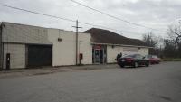
In the past few decades, the residents of Houston's Third Ward neighborhood have seen their neighborhood grocery stores go out of business, converting to night clubs or sitting vacant.
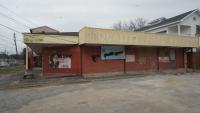
Millard's Food Market (2019) replaced by Fuzion Lounge night club (2022).
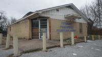
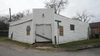
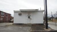
James Food Market (2015) is now abandoned (2022).
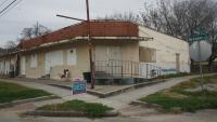
Quality Food Market (2010) is now abandoned (2022).
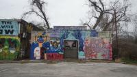
Despite the protests of local Third Ward residents, who decry the loss of their neighborhood grocery stores in the midst of increasing gentrification, new food retail options are often limited to gas stations and fast food outlets.
A sign vandalized in protest (2019) preceded a Burger King/Exxon Gas Station combo (2022).
Coinciding with a generational return to the urban core and increasing gentrification, a number of changes have occurred among the larger supermarkets surrounding Third Ward, primarily during 2019-2020.
November 7, 2019
Opening of Whole Foods Market on Elgin
Dec 17, 2019
Closing of HEB on OST @ Scott
December 18, 2019
Opening of HEB on MacGregor @ State Highway 288
July 10, 2020
Closing of Fiesta on San Jacinto @ Wheeler
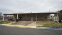
The opening of a new HEB grocery store at the intersection of N. MacGregor Way and State Highway 288 was touted by City of Houston Mayor Sylvester Turner and District D Councilmember Dwight Boykins as a solution to Third Ward's "food desert" problem. The property for the store was purchased by the City with soon-to-expire federal Economic Development Initiative funding and leased to HEB through a nonprofit. However, the property is in a census tract that is not considered food insecure, just across the highway from the wealthy Museum District neighborhood.
Of the Greater Third Ward Super Neighborhood’s six census tracts, three are officially designated as food insecure (“food desert”) areas due to low income and limited supermarket access, as designated by the U.S. Department of Agriculture. Using GIS network analysis, we calculated driving distances from all residential intersections in the neighborhood to the nearest supermarkets, all of which exist outside the boundaries of the Third Ward Super Neighborhood. We also created one-mile service delivery boundaries for each supermarket. These analyses were conducted for the supermarket landscape prior to and after 2019-2020, during which several changes occurred, including the loss of two existing supermarkets and the addition of two new stores.
The following maps show the one-mile travel distance service area for the chain grocery stores surrounding Third Ward before and after the changes that occurred in 2019-2020. The 6 census tracts that fall entirely within the boundaries of the Greater Third Ward Super Neighborhood are highlighted.
The new MacGregor HEB provides little additional service area to the Third Ward Census Tracts and any gains are more than offset by the loss of the Fiesta.
The following map shows the percent of households without a vehicle for the six census tracts in Third Ward versus the surrounding census tracts adjacent to the supermarket locations.
Not only do residents in Third Ward live further from the full-service supermarkets, they're also more than twice as likely to not have access to a vehicle. In total, more than 1,200 households in Third Ward do not have access to a vehicle.
The next map shows driving distances from Third Ward residential intersections to the nearest supermarket overlaid on USDA Low-Income/Low-Access (LI/LA) food insecurity ("food desert") designations for census tracts in Greater Third Ward Super Neighborhood and MacGregor Super Neighborhood before and after the changes of 2019-2020. The blue census tracts are low-income census tracts where a significant number or share of residents are more than 1 mile from the nearest grocery store, while the orange census tracts are low-income census tracts where more than 100 housing units do not have a vehicle and are more than ½ mile from the nearest supermarket. The green dots signify travel distances of less than 1 mile from the nearest supermarket, the yellow dots signify travel distances of 1 to 1.5 miles from the nearest supermarket, and the red dots signify travel distances of 1.5 miles or more from the nearest supermarket.
The new MacGregor HEB location primarily improved access to food (<1 mile to a store, represented by green dots) in census tracts not designated as food deserts. The blue census tracts (Low Income and Low Access - "Food Deserts") saw only an improvement along the border of one tract. Most intersections in food deserts saw their status remain as yellow (1-1.5 miles from a store) or red (1.5+ miles), and some shifted to red and suffered worsened travel distances due to the loss of the Fiesta.
The next map shows the travel distances before and after 2019-2020 within the Third Ward census tract boundaries.
Not only did the new HEB fail to improve travel distances for the residents in Third Ward, some of their travel distances worsened due to the loss of Fiesta.
The following map shows the travel distances before and after 2019-2020 overlaid on the boundaries of the 1930s Home Owners Loan Corporation (HOLC) Residential Security Map.
Both before and after the changes in 2019-2020, residents in the formerly redlined section of Third Ward experienced longer travel distances to the nearest supermarket. Though travel distances improved in the non-redlined section of Third Ward after the addition of the new MacGregor HEB, overall travel distances in the redlined section worsened due to the loss of the Fiesta.
Owned by Rice Management Company - the investment arm of Rice University - the property formerly leased to Fiesta Mart is now Greentown Labs, a clean energy tech startup incubator.
The closing of the Fiesta in 2020 was unexpected as Rice Management Company had previously promised to extend their lease and keep the store open.
Third Ward Food Desert
The COVID-19 pandemic further increased food insecurity in neighborhoods like Third Ward.
Stronger Houston: Food deserts in Houston area a widening problem amid pandemic
The current food access landscape of Third Ward is characterized by a spattering of vacant or limited-option corner stores, a proliferation of gas stations and fast food outlets, and a handful of church food pantries, non-profit programs, and community gardens striving to bridge the food access equity gap.
Community Food Market
Closed as of 2013.
McGowen @ Nagle Corner Store
Closed prior to 2007 .
Jordan Grove Missionary Baptist Church
Weekly food pantry distribution.
Quality Food Market
Closed as of 2011.
Eddy Lim Food Market
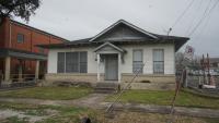
Formerly a full service neighborhood grocery with deli, Eddy Lim's now only stocks typical corner store fare.
Ennis @ Elgin Corner Store
Closed as of 2015.
Sauer @ Drew Corner Store
Closed before 2007.
ASHTH Food Pantry
The Annete Strawder Here to Help Food Pantry provides weekly grocery distribution.
T DO Food Market
T DO Food Market Closed prior to 2007.
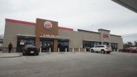
Gas Station/Burger King
New food retail options in Third Ward are limited to gas stations and fast food outlets.
Boynton United Methodist Church
Weekly food pantry distribution.
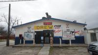
Drew Food Store
One of the few corner stores operating the University Village neighborhood of Third Ward.
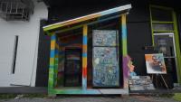
Third Ward Community Fridge
Operated by Houston Community Fridges.
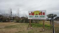
Blodgett Urban Gardens
Blodgett Urban Gardens is dedicated to sustainable gardening, healthy eating, and community education.
Riverside United Methodist Church
A Houston Food Bank Food for Change market location.
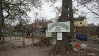
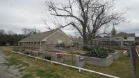
Alabama Gardens
The oldest community garden in Houston, affiliated with Urban Harvest.
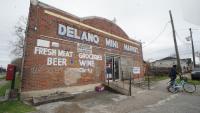
Delano Mini Market
One of the few food retail options in northern Third Ward.
Manna Food Pantry
Provides food assistance, washing detergent, baby diapers, paper products, and more.
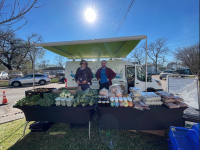
Project Row Houses
Project Row Houses has partnered with Urban Harvest Mobile Markets and Second Servings Houston to provide fresh produce and prepared meals to Third Ward neighbors in need.
Community Food Market
Closed as of 2013.
McGowen @ Nagle Corner Store
Closed prior to 2007 .
Jordan Grove Missionary Baptist Church
Weekly food pantry distribution.
Quality Food Market
Closed as of 2011.
Eddy Lim Food Market
Formerly a full service neighborhood grocery with deli, Eddy Lim's now only stocks typical corner store fare.
Ennis @ Elgin Corner Store
Closed as of 2015.
Sauer @ Drew Corner Store
Closed before 2007.
ASHTH Food Pantry
The Annete Strawder Here to Help Food Pantry provides weekly grocery distribution.
T DO Food Market
T DO Food Market Closed prior to 2007.
Gas Station/Burger King
New food retail options in Third Ward are limited to gas stations and fast food outlets.
Boynton United Methodist Church
Weekly food pantry distribution.
Drew Food Store
One of the few corner stores operating the University Village neighborhood of Third Ward.
Third Ward Community Fridge
Operated by Houston Community Fridges.
Blodgett Urban Gardens
Blodgett Urban Gardens is dedicated to sustainable gardening, healthy eating, and community education.
Riverside United Methodist Church
A Houston Food Bank Food for Change market location.
Alabama Gardens
The oldest community garden in Houston, affiliated with Urban Harvest .
Delano Mini Market
One of the few food retail options in northern Third Ward .
Manna Food Pantry
Provides food assistance , washing detergent, baby diapers, paper products, and more.
Project Row Houses
Project Row Houses has partnered with Urban Harvest Mobile Markets and Second Servings Houston to provide fresh produce and prepared meals to Third Ward neighbors in need.
Our spatial analysis found that drive times and service area coverage in Third Ward were not improved by the recent addition of new chain supermarkets on the outskirts of the neighborhood, and any potential gains were offset by the closing of more affordable supermarkets closer to the food insecure census tracts. Our results indicate that expanding the footprint of supermarkets alone, particularly in formerly redlined and disinvested urban neighborhoods, is not sufficient to mitigate food insecurity.
While federal tax incentives may lure supermarket chains into low-income inner-city neighborhoods, local initiatives can have a stronger and more immediate impact. Examples of local initiatives that can substitute or supplement the opening of a large chain supermarket include community gardens, mobile farmer markets, non-profit and faith-based pantries and markets, independent grocery stores, cooperatively owned grocery stores (co-ops), affordable online grocery delivery services, community fridges, and corner stores or gas stations with expanded selections of fresh produce and healthy food options. Such local efforts would not only provide greater access to healthier food options, but also promote greater community cohesion and economic resiliency among local residents.


